Download
1 / 11
110 likes | 115 Views
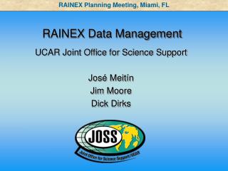
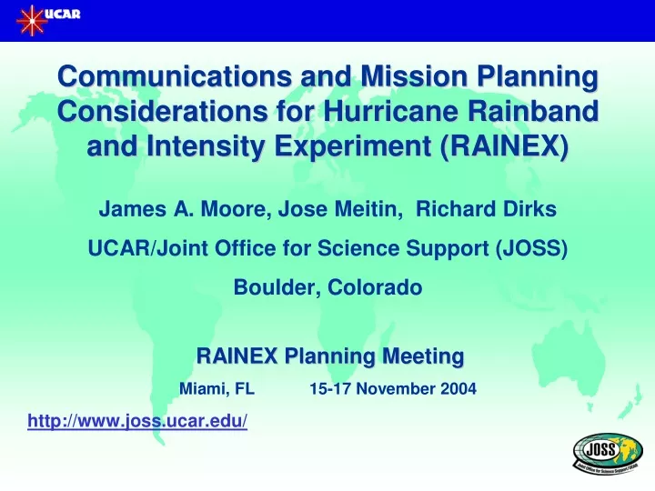
RAINEX Real time Communications Overview. VHF radio. Satcom. Satcom. Satcom. Satcom. LF, satellite Flight track Composite. Composite. Composite. LF, flight level, position data. RAINEX Operations Center Composite Generation Ops. Coordination Science Director

E N D
RAINEX Real time Communications Overview VHF radio Satcom Satcom Satcom Satcom LF, satellite Flight track Composite Composite Composite LF, flight level, position data RAINEX Operations Center Composite Generation Ops. Coordination Science Director Facility Status Zebra analyses Forecast Field Catalog Model Analysis RSMAS HRD Products Operational Products Satellite Imagery Model Products Surface Observations RECON obs Phones, Internet, FTP NHC Products Phones Internet NCAR, NOAA, Rest of the World
NOAA/AOC Support Requests for RAINEX • Capabilities aboard the RAINEX NOAA P-3 aircraft should be the same as those available during the BAMEX Project. • LF radar packets on aircraft LAN • Project provided computer for radar processing • Project provided processing software • Radar data products • Preferred data stream in compressed and geo-referenced format for continuous download to Operations Center. This would give the operations folks the most flexibility to prepare a composite image with satellite, aircraft track and annotation. Several considerations here including size of the datastream, practicality for continuous download, etc. • Possible compressed gridded format radar data file of a single 360 sweep from LF radar. Complete gridded file to be downloaded each 5 minutes to the Operations Center. • Need to determine compressed data stream and/or gridded product file size • Need to determine real (as opposed to advertised) download rate via satellite system • Download aircraft position and flight level (selected) data • Install chat and configure for flight scientist use aboard both aircraft
NRL Support Requests for RAINEX (Communications Related) • Capabilities aboard the RAINEX NRL P-3 aircraft should be the same as those available during the BAMEX Project. • Position information and selected flight level data to be continuously downloaded to Operations Center • Chat capabilities to be available for flight scientist use aboard the aircraft. • Other capabilities to aid real time coordination: • Provide display on the aircraft for the ELDORA scientist position and possibly on the flight deck • Need to determine real (as opposed to advertised) upload rate via satellite system. (This has a major bearing on the size frequency of image that can be provided to update NOAA LF radar, satellite and flight track composite) • .
Operations Center Real time Support Tasks • Data and products to be downloaded from aircraft include: • All aircraft position, • All aircraft flight level data, • LF radar data in radar format (continuous) or compressed gridded file (~5 minute intervals) from NOAA aircraft • Other data and products include: • High-resolution GOES in normal or rapid scan mode. • Other special products from various sources (e.g. HRD/NHC) • Products Uploaded to aircraft: • Satellite/NOAA LF radar composite with completed aircraft track information back 30 minutes and proposed future track of NRL out 30 minutes (including direction and end points) Other annotation including hurricane motion, band rotation and cell propagation information should be included. • Other general information including cell/band intensification, new growth, etc. via separate schematic diagram or chat • In the absence of LF radar data in the vicinity of NRL, provide satellite image with annotation as noted above.
Summary of Key Communications Issues • LF radar data availability on NOAA P-3 aircraft LAN • Actual Bandwidth capacities on all aircraft • Interface RAINEX provided computers on NOAA aircraft • Real-time availability of aircraft track information • Transmission of LF geo-referenced data or product to the operations center • Determination of realistic composite product update rate
RAINEX Mission Planning Process NHC Operations Tasking NOAA/AOC P-3 Aircraft scheduled as needed with single/double crews and special measurement requirements CARCAH/NHC/HRD Alert (nominal 1300 UTC) 48 h ahead Nominal NOAA/AOC G-4 surveillance missions (centered on OO, 12 UTC synoptic times) FAA alert (nominal) 12 18 00 06 12 18 00 06 12 18 00 06 12 18 00 UTC Local time (EDT) 08 14 20 02 08 14 20 02 08 14 20 02 08 14 20 HRD/RAINEX Daily Briefing (1630 UTC nominal) HRD/RAINEX Daily Briefing HRD/RAINEX Daily Briefing NRL operations with P-3 flights (nominal 30 min T/O delay) NRL operation (24 h cycle) NRL P-3 Ferry to AOC in Tampa based on Alert timing RAINEX Research Support
RAINEX Mission Planning Key Considerations • Alert sequence and lead times for RAINEX proposed operations • Timing of staging of NRL P-3 to AOC • Flight track planning and updating (radar and dropsondes) • Departure sequence for NOAA and NRL aircraft • Collaboration on dropsonde mission planning with NHC/HRD (advanced) • Dropsonde coordination (real-time) • Mission planning process with contingencies in play (e.g. deployment with Caribbean or Pacific Ocean ops)