Download
1 / 10
100 likes | 221 Views
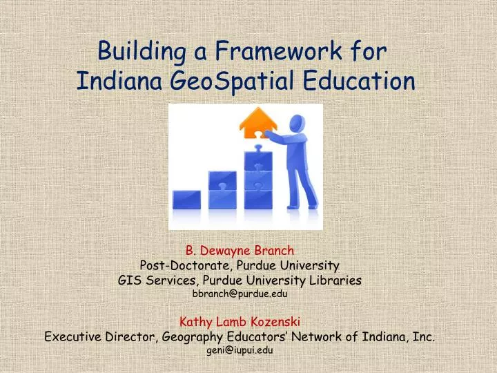
Building a Framework for Indiana GeoSpatial Education. B. Dewayne Branch Post-Doctorate, Purdue University GIS Services, Purdue University Libraries bbranch@purdue.edu Kathy Lamb Kozenski Executive Director, Geography Educators’ Network of Indiana, Inc. geni@iupui.edu. PRESENTATION.

E N D
Building a Framework for Indiana GeoSpatial Education B. Dewayne Branch Post-Doctorate, Purdue University GIS Services, Purdue University Libraries bbranch@purdue.edu Kathy Lamb Kozenski Executive Director, Geography Educators’ Network of Indiana, Inc. geni@iupui.edu
PRESENTATION Purpose of Discussion Higher Level Goals Detailed Justification for GIS/GeoSpatial Learning Major Action Steps Action Step 1 & 2: Survey Draft Participation ? Mapping Learning Objectives and Geospatial Data
I. PURPOSE • Why an Indiana geospatial technologies K-12 educational framework? • To address state GIS workforce capacity and innovation, and to • elevate Indiana as a prominent national leader in spatial data education: • knowledge, skills, applications, research, and provider. • Why are we having a state GIS Conference? • What critical skills are we seeing here at our conference that • may be transferable to the K-12 arena, • are seen as vital, and • are measured in terms of math, science, or social sciences learning? • What funds ---- that are already utilized in geospatial technology fields for a • variety of data acquisition, management, and research ---- could reduce learning • costs for K-12 students and educators in regards to professional development • and curriculum creation?
II. HIGHER LEVEL GOALS Making K-12 GIS/geospatial learning sustainable Effective teacher training Identifying geospatial data champions Identifying Indiana state government spatial data advocates √ Identifying university K-12 educational advocates Intentional K-12 acknowledgement of GIS use and learning collaboration on spatial data in terms of math, science, reading and social sciences learning Step 1 Step 2
Challenges to adding GIS or geospatial learning to the existing K-12 curriculum: • Lack of time: school day and school year • Lack of funding for professional development • Lack of funding to create dynamic and appropriate curriculum materials • Energy to make it sustainable • Need geospatial data champions at local, city, and state levels • Indiana state government spatial data advocates… Where are they? • University geospatial advocates to support K-12 education transfer • Need MORE K-12 learning collaboration regarding spatial data in terms of • math, science, reading/writing, and social studies/sciences learning • Paradigm shift >>> changes that the • state political machinery might not • be ready to address and citizens • might not understand ... Connecting • real, 21st Century employment • knowledge, skills, applications, and • research to the K-12 curriculum.
III. DETAILED JUSTIFICATION for GIS/GeoSpatial Learning • Everyone Benefits • from a geospatial technologies perspective • from a data learning perspective • Agricultural community • Business • Economics • Employee pipeline • STEM education pipeline • Local, City/County, State, Federal Government • Citizens • Now is the time to grow the cause of purposeful • and intentional K-12 geospatial technologies education • in Indiana!
Next biggest issues in Geospatial Learning … • Drones as learning and data dissemination tools • Using public spatial data to build a greater spatial literacy • Educator training and educational acceptance of spatial cognition • Assets already available … • GIO IGIC INView IGS IN Spatial Data Portal INMap Polis Center • GENI ICSS ICEE IESTA HASTI and more • K-12 curriculum inclusion – IN and national (Social Studies/Geography, English/ • Language Arts, Science, Technology): late ‘90’s to present • GeoSpatial Technologies for IN Educators and Students website • http://www.iupui.edu/~gst • Curriculum • IN/ESRI Statewide Site License for K-12 Purposes • Amazing research and applications at post-secondary institutions and within • government and private businesses: DNR, IGS, IDoT, ISDH… • YOU, YOU, YOU
IV. MAJOR ACTION STEPS • A surveythat connects educators to the Indiana geospatial workforce √ • Crowd sourced research effort with Purdue, IUPUI & other to promote GIS/ • geospatial learning on a long-term basis √ • Establish a network for university, state agency, and education stakeholders • for more in-depth action in the next year √ • Utilize area GIS Days to disseminate geospatial teacher training or summer • data science engagement opportunities √ • A collaboration to map learning objectives to geospatial data √ • An educational recognition of spatial cognition as learning modality via • the National Academy of Sciences √ = doable working together = challenging to improve networking To share ideas and become engaged, contact Dewayne Branch at bbranch@purdue.edu THANK YOU!
V. ACTION STEPS 1 & 2 Do you want to assist with creating (or participating in) a short survey to capture information about connecting educators & IN geospatial technology specialists? 2. collaborating to map IN learning objectives/ academic standards to geospatial technologies?
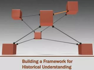
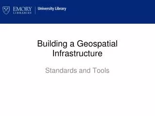
Framework for GeoSpatial Technologies Integration: GIS Resource Specialist as Facilitator, Purdue University as a Model Elected officials & decision-makers (Daniels, Klinker) Educators professional development, curricula creation, connect to faculty & research, bridge between h.s. students & university (McCutcheon High School) Researchers Ag, Engineering Education, Economics, Atmospheric Physics (Larry Biehl – MultiSpec) Geo Geospatial Tools professionals GIS Resource Specialist (Branch) Students middle & high schools, post-secondary, classroom experiences, field work, visits to/from university access to opportunities (Steve Smith – IESTA) ESRI INMap Developers & Creators software/applications, students, faculty, projects, colleagues (Jinha Jung – LiDAR & Google) SAVI literature educators researchers webinars EducationOutreach Organizations GENI, ICEE, IESTA, HASTI, ICSS, (Sanson, Smith, Branch, Jones) IN Geographic Information Officer local, city, county, state, federal, Governor, elected officials (Daniels, Biehl) IGIC local, city, county, state, federal, resources, employment, citizens, business leaders, decision-makers (Biehl, Smith, Branch)