Download
1 / 1
10 likes | 122 Views
Johan Ploug Technical University of Denmark, Department of Civil Engineering , Arctic Technology Centre.

E N D
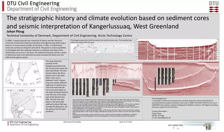
Johan Ploug TechnicalUniversity of Denmark, Department of Civil Engineering, ArcticTechnology Centre In 2008, a research group from University of Aarhus and the Technical University of Denmark sailed the full extent of Kangerlussuaq while using a boomer, to shoot seismic profiles of the fjord. In 1991, a multichannel study was carried out along the same fjord. This grants a unique possibility to investigate both the sediment thickness on bedrock and some of the sedimentary structures in the fjord. The sediment thickness will be a means to determine how much sediment has been provided the fjord since the LGM and the glacial retreat. The stratigraphic history and climate evolution based on sediment cores and seismic interpretation of Kangerlussuaq, West Greenland The Kangerlussuaq Fjord with the seismic line and the threecores. The Sarfatôq River outlet just south of the firstcore The maps show the position of the Kangerlussuaq fjord and the central inset shows the fjord specifically. The dots denote where the three gravity cores have been taken. Each core is between 4 and 5 meters long, but contain different segments of sedimentary mud and sand intervals. Two cores were taken on the large laminated feature near the end of the deep part of the fjord (to the left). The last core was taken in the laminated sediments about half way through the deep part, see the seismic line for exact positions. Two cores from the sediment structure depicted in the inset. They contain little shell material, but show a distinct lamination in the muddy layers, and a distinct interbedding with coarser sand intervals. The coarser material is either slumps from the fjord sides and from the nearby Sarfartôq River. The core from the deep laminated part of the fjord contains many shell fragments. 14C has been sampled from the shells and have shown a short timespan of just 1000 years through the core. Coupling the sedimentation rate with the amount of sediment in the fjord, we hope to establish a better interpretation of the deglaciation in the Kangerlussuaq fjord. The gaps in the cores represent samples taken for OSL dating. We have tried to take top and base samples where applicable in order to get full ages, although the margin of error is high on a short time span of 1000 years. XRF core scans have been made on the three cores. Further work encompass correlating the sediment stratigraphy with biostratigraphy and chemostratigraphy to show the climate evolution through the deglaciation. Acknowledgements: I wouldlike to thank the Commission for Scientific Research in Greenland (KVUG) for providingfinancial support during the ship cruise in 2008. IHS (former SMT) for the use of KINGDOM Suite software. Morten Holtegaard for Matlab assistance. DTU Byg for providingfinancialsupport for the PhDthesis. Contact information: Johan Ploug ARTEK, DTU Byg E-mail: joplo@byg.dtu.dk EGU General Assembly April 23-27 2012