Download
1 / 50
510 likes | 538 Views
Little Pine Creek Watershed Tour Susquehanna River Water Basin.

E N D
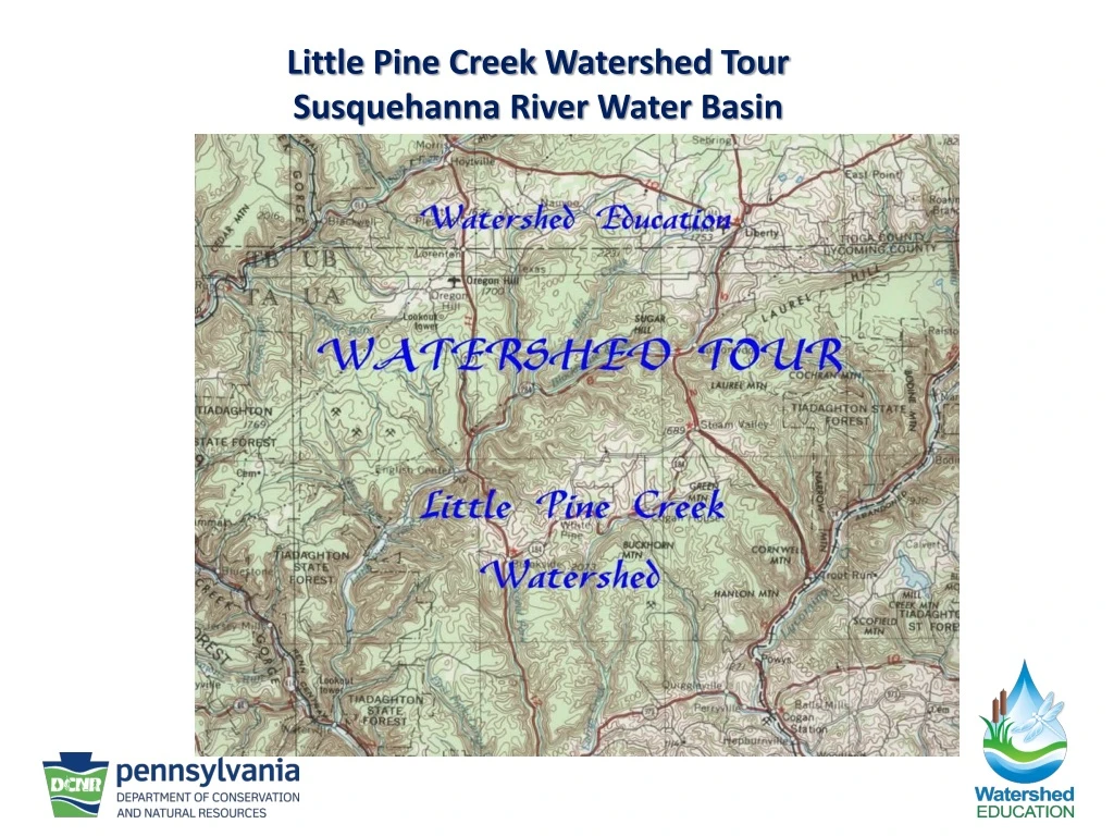
Little Pine Creek Watershed TourSusquehanna River Water Basin
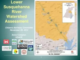
Little Pine Creek flows into Pine Creek at the village of Waterville. Pine Creek flows into the West Branch Susquehanna River just west of Jersey Shore. The West Branch and the North Branch join near Sunbury to form the main stem of the Susquehanna River. The Susquehanna River empties into the Chesapeake Bay.
Approximately 80% of the Little Pine Creek watershed is in Lycoming County, with the remainder in Tioga County.
This historic photo shows the confluence of Little Pine Creek and Pine Creek. Little Pine Creek is the one with the bridge.
John English, a Revolutionary War veteran, was the first settler in the Waterville area.
John English, Thomas Ramsey, and Claudius Boatman, all Revolutionary War veterans, are buried on an island in Pine Creek, just south of Waterville.
The logging era virtually stripped the land of trees. Although this photo is not in the Little Pine Creek watershed, it shows the typical deforestation.
Many small railroads were built in north-central Pennsylvania to haul logs. Note that there is no railroad along Little Pine Creek.
Instead of a railroad, logs were floated down Little Pine Creek, in so-called “log drives”. Note the raft on the left side of the picture.
In the foreground is the sign at the entrance to the Happy Acres campground, a private campground with both permanent and temporary sites. Happy Acres restaurant is in the background.
The campground at Little Pine State Park is open from the first full weekend in April to mid-November. There are 104 sites, plus four Organized Group Tenting sites.
The campground was built on the site of a former Civilian Conservation Corps camp, known as the Gifford Pinchot Camp.
The campground is also located on the site of a former lumbering village called English Mills. The village cemetery is located in the middle of the campground, and holds the remains of several prominent settler families.
The dam that creates Little Pine Lake was built in 1949-1950 as a flood control dam.
In 2005, the lake was completely drained to perform maintenance on the outlet structure of the dam. Note the almost featureless nature of the lake bottom.
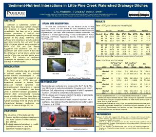
Unfortunately, the lake also acts as a sediment trap. As the lake was being drained, much sediment was carried downstream. This is the settling basin, where the water comes out of the dam. The basin would normally be about 14 feet deep at the deepest point.
Little Pine State Park, in cooperation with the Pennsylvania Game Commission, has established several food and cover plots for wildlife. These are located at the north end of the park, in old agricultural fields.
The northern border of the state park is at the confluence of Otter Run with Little Pine Creek. At one time, Otter Run was so polluted that there was no animal life in the stream.
Otter Run is a third-order stream. Note the three mine symbols in the northern half of the watershed. More on them later.
Do you remember the raft seen in slide # 12? The rafts could be 20 feet wide by 50 feet long. The only way to float such rafts on Little Pine Creek was to create artificial floods by the use of splash dams. There were four splash dams in the Little Pine Creek watershed. When a log drive was organized, water would be released from the dams. The releases were timed so that all the water would converge to create the highest flood crest.
This is the site of the former Otter Run splash dam. Little physical evidence remains.
This is one of the few remaining agricultural areas west of PA Rt. 287. This is about ¼ - mile downstream from English Center.
English Run (north) is a third-order stream that enters Little Pine Creek at the south end of English Center.
This is English Run Road, at the south end of English Center. This road leads to the Fisher Mining Corporation operation.
English Run Road also provides access to a large part of State Game Lands # 75.
In the mid-1800’s, coal was discovered and mined. The original mines were deep shaft mines. Eventually, the mines became so deep that pumps could not deal with the water in the mines. The mines were then abandoned. This later caused the acid mine drainage (AMD) that devastated Otter Run.
In the 1970’s, the Pennsylvania Game Commission awarded the new owner of the Fisher Mining Corporation a contract to strip mine the area. Terms of the contract included AMD remediation and surface reclamation. In the foreground you can see some of the reclaimed area, and in the background the active strip mine.
The village of English Center was established as a logging town. After the loggers left, a tannery was established. The effluent from this was another source of pollution for the creek.
North of English Center, most of the Little Pine Creek watershed lies east of Rt. 287, towards Buttonwood.
This small tributary is important because it is the drainage in which the Ski Sawmill resort is located.
During the winter, the resort makes snow to create the base for the ski slopes.
In the spring, this snow pack provides an extended meltwater period, feeding Bonnell Run.
One effect of winter is the spreading of road salt. This, along with agricultural runoff, is one of the sources of non-point-source pollution in the watershed.
Little Pine Creek officially begins at the confluence of Texas Creek and Blockhouse Creek, along Rt. 284.
Texas Creek is the 2nd largest of the three main headwater streams.
The opening of the Marcellus Shale Play to natural gas drilling has created an important economic force in the region. This pad is located along Rt. 284.
One concern is the possibility of chemical contamination of the creek from traffic accidents.
This map shows the major sub-watersheds that make up the Little Pine Creek watershed.
Although Little Pine Creek was once a major transportation route, that use is now mainly recreational……..
We hope that you have enjoyed this tour of the Little Pine Creek watershed.