Download
1 / 36
380 likes | 720 Views
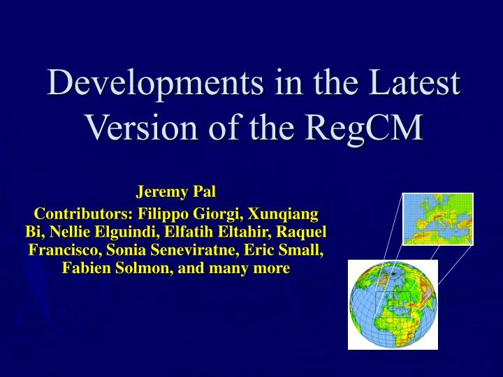
Developments in the Latest Version of the RegCM. Jeremy Pal Contributors: Filippo Giorgi, Xunqiang Bi, Nellie Elguindi, Elfatih Eltahir, Raquel Francisco, Sonia Seneviratne, Eric Small, Fabien Solmon, and many more. Latest Developments. User-friendliness Preprocessor Terrain and landuse

E N D
Developments in the Latest Version of the RegCM Jeremy Pal Contributors: Filippo Giorgi, Xunqiang Bi, Nellie Elguindi, Elfatih Eltahir, Raquel Francisco, Sonia Seneviratne, Eric Small, Fabien Solmon, and many more
Latest Developments • User-friendliness • Preprocessor • Terrain and landuse • Initial and boundary conditions • Model Physics • Large-scale and convective precipitation • Land-surface and ocean • Postprocessor • Output formats
Latest Developments: Input/Output • User-Friendly • Landuse and Topography • USGS GLCC 30 second (~1-km) Landuse data • Based on AVHRR • Now 20 vegetation types (previously 13) • USGS GTOPO30 30 second (~1-km) Elevation data • Initial and Boundary Conditions • Reanalysis Data: NCEP and ECMWF • GCM Data: HadCM and CCM3 • SST Data: 1° CAC Optimal Interpolation and 1° Hadley Centre • Rotated Mercator Map Projection • Suitable for most latitudes • More Compact Data formats • GrADS compatible (real*4 direct access) • NetCDF Processors (real*4 and integer*2) • Vis5D
GLCC Vegetation Reanalysis & GCM Initial and Boundary Conditions Rotated Mercator Projection USGS Topography Improvements to Structure & Input Hadley & OI Sea Surface Temperatures
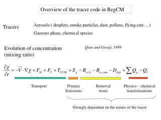
Latest Developments: Core Model • Tracer/Aerosol Scheme [Qian et al (2001); Solmon] • Zeng et al (1998) Ocean Flux Model • SUBEX Large-scale Precipitation Scheme (Pal et al 2000) • Emanuel (1991) Convection Scheme • Sub-grid Land Surface and Precipitation Parameterization [Giorgi et al (2003); Pal and Elguindi]** • Non-Hydrostatic [Bi]** • Parallel Code [Ye and Bi]** ** To be released by the end of the summer.
Latest Developments: Core Model • Tracer/Aerosol Scheme [Qian et al (2001); Solmon] • Zeng et al (1998) Ocean Flux Model • SUBEX Large-scale Precipitation Scheme (Pal et al 2000) • Covection: FC80 Closure; Emanuel (1991) Scheme • Sub-grid Land Surface and Precipitation Parameterization [Giorgi et al (2003); Pal and Elguindi]** • Non-Hydrostatic [Bi]** • Parallel Code [Ye and Bi]** ** To be released by the end of the summer.
Regional Climate Model Winds, PBL Processes Clouds, Precipitation Clouds, Temperature, Water Vapor Aerosol Model Source, Transport, Removal Radiative Fluxes Heating Rate Aerosol Radiative Forcing Aerosol Concentration Radiative Transfer Package Adapted from Qian et al (2001) Tracer/Aerosol Scheme • Transport • Advection/Diffusion • Convection • Emissions • Removal processes • Precipitation (large-scale and convective) • Dry deposition • Chemistry scheme for Sulfates • Direct and indirect radiative effects
Anthropogenic Aerosols overEast Asia (Giorgi et al. 2002) • Summer cooling has been observed in recent decades over many regions of East Asia. • At the same time, anthropogenic sulfate and fossil fuel soot emissions have drastically increased due to the economic development of the region. • This study investigates the impact of sulfur and soot emissions from fossil fuel burning on the regional climate of East Asia. • Intercomparison of 5-year simulations (1993-1997) with and without aerosol effects.
Anthropogenic Aerosols over East Asia • In recent decades, the anthropogenic sulfate and fossil fuel soot emission over east Asia have drastically increased. • At the same time, summer cooling has been observed over the major emissions regions. • This study assesses the surface climatic effects of this emissions.
Sulfur emission over East Asia (g S m-2 yr-1)
Temperature difference between between the periods 1981-1998 and 1951-1980.
Effects of Aerosols on Temperature and Precipitation Temperature Differences Precipitation Differences
Summary of Impacts of East Asian Anthropogenic Emissions • The anthropogenic emissions over East Asia tend to cause surface cooling and inhibit precipitation. • Some features of the simulated aerosol-induced surface cooling are consistent with temperature trends observed in recent decades over different regions of East Asia.
Latest Developments: Core Model • Tracer/Aerosol Scheme [Qian et al (2001); Solmon] • Zeng et al (1998) Ocean Flux Model • SUBEX Large-scale Precipitation Scheme (Pal et al 2000) • Covection: FC80 Closure; Emanuel (1991) Scheme • Sub-grid Land Surface and Precipitation Parameterization [Giorgi et al (2003); Pal and Elguindi]** • Non-Hydrostatic [Bi]** • Parallel Code [Ye and Bi]** • ** To be released by the end of the summer.
The old bulk aerodynamic algorithm uses the Monin-Obukhov similarity relations without special treatments of convective or very stable conditions. Overestimate latent heat in both weak and strong wind conditions The new algorithm describes all stability conditions and includes a gustiness velocity to account for the additional flux induced by boundary layer scale variability RegCM: BATS RegCM: Zeng RegCM: BATS-Zeng Zeng et al (1998) Ocean Flux Scheme
Latest Developments: Core Model • Tracer/Aerosol Scheme [Qian et al (2001); Solmon] • Zeng et al (1998) Ocean Flux Model • SUBEX Large-scale Precipitation Scheme (Pal et al 2000) • Covection: FC80 Closure; Emanuel (1991) Scheme • Sub-grid Land Surface and Precipitation Parameterization [Giorgi et al (2003); Pal and Elguindi]** • Non-Hydrostatic [Bi]** • Parallel Code [Ye and Bi]** ** To be released by the end of the summer.
Importance of Clouds • Correctly simulating the surface solar radiation is crucial in simulating the hydrologic cycle. • The response of climate to changes in CO2, soil moisture, vegetation, etc., is largely dependent on cloud feedbacks. • E.g. The IPCC report indicates that the representation of cloud characteristics accounts for a large portion of the uncertainty in climate change predictions. • In most climate models clouds and precipitation are represented in two forms • Resolvable (large-scale) • Unresolvable (convective)
Surface Temperature (RegCM vs OBS) Incident Solar (RegCM vs OBS) Large-Scale Clouds and Precipitation • The model had an on-off tendency with clouds. • No middle ground • Clouds only form when the gridcell is supersaturated. • Clouds often exist at relative humidities below one. • Fractional cloud cover (FC) is 80% when cloud water exists and 0% otherwise. • FC varies between 0 and 100%. • Raindrop accretion & evaporation are not accounted for.
SUBEX: Map of Domain Landuse and Elevation
Old Model vs. Observations New Model vs. Observations SUBEX:Incident Surface Solar (NASA-SRB)
Old Model vs. Observations New Model vs. Observations SUBEX:Mean Surface Temperature (USHCN)
Old Model vs. Observations New Model vs. Observations SUBEX:Precipitation (USHCN)
SUBEX:June & July 1993 Flood USHCN Observations RegCM: New Model RegCM: Old Model
SUBEX: Summary of Results • SUBEX provides a more accurate representation of the fields describing the energy and water budgets. • The improvements are seen in mean conditions as well as the variability at the daily to interannual scales • This suggests that SUBEX improves the model sensitivity which is critical to climate change and process studies.
Latest Developments: Core Model • Tracer/Aerosol Scheme [Qian et al (2001); Solmon] • Zeng et al (1998) Ocean Flux Model • SUBEX Large-scale Precipitation Scheme (Pal et al 2000) • Covection: FC80 Closure; Emanuel (1991) Scheme • Sub-grid Land Surface and Precipitation Parameterization [Giorgi et al (2003); Pal and Elguindi]** • Non-Hydrostatic [Bi]** • Parallel Code [Ye and Bi]** ** To be released by the end of the summer.
Convective Processes • Convective processes occur at horizontal scales on the order of 1-km. • RCMs and GCMs typically run at resolutions 1-2 orders of magnitude greater. • Most models are thus required to parameterize convection making the assumption that the statistical properties of convection can be deduced from the large-scale (resolved) variables. • In models, an inadequate representation of convective can significantly increase the uncertainty of the model predictions.
Grell Scheme Description • Simplified form of the Arakawa & Schubert (1974) convection scheme • Convective clouds consist of an updraft and downdraft circulation. • The updraft and downdraft origins occur at the levels of maximum and minimum moist static energy. • The scheme is activated when a lifted parcel attains moist convection.
Quasi-Equilibrium Assumption (Arakawa & Schubert 1980; AS74): Convection stabilizes the environment as fast as the large-scale destabilizes it. Designed to represent Type II (Tropical) convection which tends to be the most common form of convection. Default in Grell Scheme. Fritsch & Chappell (1980) Closure Assumption (FC80) Convection removes the available buoyant energy at a given time-scale. Designed to represent Type I (explosive) convection which typically occurs in mid-latitudes. Grell Scheme Closure Assumptions
Convective Closure Assumptions:June & July 1993 Flood USHCN Observations RegCM: FC80 RegCM: AS74
Emanuel Convection Scheme • Arguably a more physical representation of convection than the Grell and Anthes-Kuo schemes. • Designed to represent the effects of all moist convection, including shallow, non-precipitating cumulus. • Includes the tracer transport options. • More testing of the Emanuel Scheme within the RegCM3 is required. • Stable only at small timesteps.
Latest Developments: Core Model • Tracer/Aerosol Scheme [Qian et al (2001); Solmon] • Zeng et al (1998) Ocean Flux Model • SUBEX Large-scale Precipitation Scheme (Pal et al 2000) • Covection: FC80 Closure; Emanuel (1991) Scheme • Sub-grid Land Surface and Precipitation Parameterization [Giorgi et al (2003); Pal and Elguindi]** • Non-Hydrostatic [Bi]** • Parallel Code [Ye and Bi]** ** To be released by the end of the summer.
Subgrid Topography and Landuse Scheme • Land surfaces are characterized by pronounced spatial heterogeneity that span a wide range of scales (down to 100s of meters). • Topography and landuse exert a strong forcing on atmospheric circulations and land-atmosphere exchanges. • Current climate models cannot capture the full range of scales, thus intermediate techniques can be used. 60-km 10-km
60-km Landuse 60-km Topography 10-km Landuse 10-km Topography
General Methodology • Disaggregate atmospheric fields from the coarse grid to the fine grid surface. • Extension of approach of Seth et al. (1994) • Landuse, topography, and soil texture are characterized on the fine grid. • Disaggregation technique is based on the elevation differences between the coarse grid and the fine grid. • Perform surface physics computations. • Reaggregate the surface fields from the fine grid to the coarse grid. • We apply this method to a regional climate model (named RegCM) using BATS.
Summary of RegCM3 Input • User-friendly • Lateral Boundary and Initial Conditions • Reanalysis: 1. ECMWF; 2. NCEP • GCM: 1. HadCM3; 2. CCM3 • Sea-surface temperatures: 1. CAC OI; 2. Hadley Centre. • Landuse: USGS GLCC (Loveland et al 1999) • Topography: USGS GTOPO30 • Map Projections: 1. Rotated Mercator; 2. Lambert Conformal; 3. Polar Stereographic
Summary of RegCM3 Core • Dynamics: 1. MM5 Hydrostatic Dynamics (Grell et al. 1994); 2. Non-hydrostatic (Bi) • Radiation: CCM3 (Kiehl 1996) • Large-Scale Clouds & Precipitaion: SUBEX (Pal et al 2000) • Cumulus convection: 1. Grell (1993); 2. Anthes-Kuo (1977); 3. Emanuel (1991) • Tracers/Aerosols: Qian et al (2001); Solmon • Boundary Layer: Holtslag (1990) • Land Surface: 1. BATS (Dickinson et al. 1986); 2. Subgrid BATS (Giorgi et al 2003) • Ocean Fluxes: 1. Zeng et al (1998; 2. BATS • Parallel Code (Ye & Bi)