Download
1 / 15
160 likes | 243 Views
Geocoding Workgroup Brief. MnGeo Statewide Advisory Council December 29, 2010. Mike Dolbow Workgroup Co-Chair. Reason for Being. Applied Geographics identified as a strategic investment for MnGeo:

E N D
Geocoding Workgroup Brief MnGeo Statewide Advisory Council December 29, 2010 Mike Dolbow Workgroup Co-Chair
Reason for Being Applied Geographics identified as a strategic investment for MnGeo: “the need for accurate and current statewide addressing, and an attendant geocoding web service, was identified by virtually all state agencies” -- Final Program Design Report, section 5.2.3http://www.gis.state.mn.us/committee/MSDI/dte/Pr ogramDesign_FinalFeb09_V21.pdf
Also… The 2010 Legislature increased standards for transparency, partly by ensuring that: “all geospatial data conform to an approved state geocode model.” -- 2010 Minnesota Statutes 16E.05, Subd. 4 (3) https://www.revisor.mn.gov/statutes/?id=16E.05
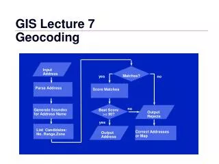
Define Geocoding The process of finding geographic coordinates from other geographic data, such as street addresses or zip codes.
Data vs. Geocoding Support Data Data: 707 Cook Ave E, St. Paul, MN Support Data: Parcels, Centerlines, etc. Result: 44.973158,-93.070529
Existing Options • Google Maps – limitations on numbers, must be on a public site • ESRI – not developed with local data • MetroGIS – not statewide, no batch
Who is Geocoding? • State Agencies • Local Governments • Non Profits • Research Groups • Federal Governments • …Who isn’t geocoding?
Geocoding Workgroup • Mike Dolbow, MDA • Kent Treichel, Revenue • Mary Arvesen, DHS • Bob Basques, St. Paul • Brad Anderson, Moorhead • Brad Neuhauser, SOS • Jessica Fendos, DEED • Jessica Deegan, MN Housing • Jennifer Johnson, DOC • Sandi Kuitunen, MnGeo • Paula Lindgren, MDH • Lee Meilleur, LCC • Fred Logman, MnGeo • Tim Zimmerman, Hennepin County • John Wiersma, DHS • Will Craig, U of M
Efforts to Date • Workgroup Charter created • Work plan / milestones created from charter • “Ideal” service requirements document created • Potential benefits drafted
Next Steps • Identify potential solutions with an RFI • Any innovative solutions out there? • What would they cost? • What data would they require (and what would that cost)? • Would it be a product (software code) or a service (hosted solution)?
Next Steps cont. • Assess costs of potential solutions • Initial • Ongoing • Compare to current • Brief Cost/Benefit analysis
Next Steps cont. • Assess and acquire potential support data sets • Recommend a solution to be developed or acquired • Report and present findings to MnGeo Advisory Councils
Timeline • Best case scenario: • RFI Posted by 1/31/2011 • RFI Results by 3/31/2011 • Support data assessment in interim • Recommendations by 6/30/2011
More Information http://www.mngeo.state.mn.us/workgroup/geocoding/
Q&A • Who in the room has a need for geocoding? • Is anyone paying for a solution (or support data)? • Are locals willing to contribute data to a statewide solution? • What kinds of solutions are used?