Download
1 / 11
120 likes | 287 Views
Beginning Geocoding. Beginning Geocoding. Getting Started Understanding the theory Create Address Locator Geocode Introduction to more advanced methods. Beginning Geocoding. What is geocoding? Definition – The process of converting an address to a specific point location on a map.

E N D
Beginning Geocoding • Getting Started • Understanding the theory • Create Address Locator • Geocode • Introduction to more advanced methods
Beginning Geocoding What is geocoding? • Definition – The process of converting an address to a specific point location on a map. Gathering data • Streets (Reference data) • Table of student information (Address table)
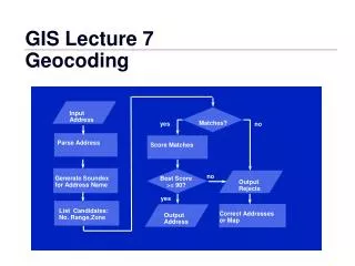
75 300 NEW YORK 399 N 301 398 ST Beginning Geocoding Matching and Scoring Address Components Address 380 New York Street Reference theme Score LeftFrom LeftTo RightFrom RightTo StreetName Type SufDir Missing component results in lower match score
Beginning Geocoding The Geocoding Process • Create a new address locator • Geocode addresses in a table • Rematch addressees interactively
Beginning Geocoding Create a New Address Locator • An address locator converts textual descriptions of locations into geographic features. • Automatically builds a geocoding index. • Create in ArcCatalog
Beginning Geocoding Create Address Locator • Choose an address style • Pick a primary reference table • Modify address locator properties • Set a 30 foot side offset and 3% end offset!!
Beginning Geocoding Geocode Addresses: • Geocode in ArcMap • Choose an address locator • Specify the fields to use in the student address table • Name the output feature class • Begin geocoding
Beginning Geocoding Rematch Addressees Interactively • Open ArcMap to review addresses geographically. Can also rematch in ArcCatalog. • Start editing • Modify and select candidates • No need to save map document!!
Beginning Geocoding Interactive Review Dialog Window
75 300 NEW YORK 399 N 301 398 ST Beginning Geocoding Matching and Scoring Address Components Address (ArcView interprets as) 380 House number New York Street name Street Street type Reference theme Score LeftFrom LeftTo RightFrom RightTo StreetName Type SufDir Missing component results in lower match score