Download

1 / 58
580 likes | 700 Views
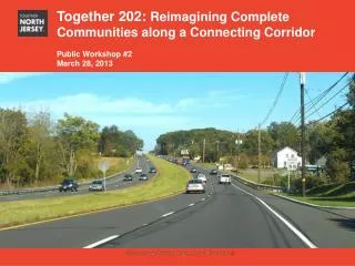
Together 202: Reimagining Complete Communities along a Connecting Corridor Final Presentation May 20, 2013. Section title. Subtitle. What is Together North Jersey ? A planning initiative in the 13-county NJTPA region of New Jersey

E N D
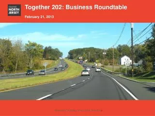
Together 202: Reimagining Complete Communities along a Connecting Corridor Final Presentation May 20, 2013 Section title Subtitle
What is Together North Jersey? • A planning initiative in the 13-county NJTPA region of New Jersey • In Nov 2011, US HUD awarded TNJ a $5 million grant to develop a Regional Plan for Sustainable Development (RPSD) • Comprehensive and balanced plan will invest in the region’s existing communities where housing, jobs, educational, cultural, and recreational opportunities are made more easily accessible to most residents without having to drive to them Together North Jersey
What are Local Demonstration Projects? • Provide technical assistance to local partners throughout Northern NJ to undertake strategic planning activities promoting sustainable and livable, transit-oriented development and advance the broader goals of the RPSD • Potential LDP projects include a variety of local planning activities to make transit corridors and communities more livable Local Demonstration Projects
Project Team: • Regional Plan Association • The Williams Group • NJ Transit • NJTPA • Project Partners: • Somerset County • NORWESCAP • Somerset County Business Partnership • Hunterdon County Chamber of Commerce • Raritan Valley Community College • HART TMA • Ridewise TMA • Flemington Borough • Trans Bridge • Hunterdon County • Bridgewater Township • Somerville Borough • Raritan Borough • Branchburg Township • Readington Township • Raritan Township Project Team & Partners
Project Objectives This project proposes to: Foster a working and collaborative network Develop a deep understanding of the Route 202 Corridor Develop a local-driven vision for the corridor
Stakeholder-Identified Goals Getting Places Expanding Economic Opportunities Make recommendations for existing businesses to capitalize on transit/corridor improvements Connect workers, residents and employees to key employment and commercial destinations through enhanced transit
Stakeholder-Identified Goals Growing in Place Working Together Work closely with state agencies to implement recommendations Identify target opportunity sites for redevelopment, reinvention or repositioning
Stakeholder-Identified Goals Keeping Healthy, Safe & Vibrant Find ways to improve connectivity along the corridor
Project Scope • Phase I: Research & Analysis – Where are we now? Where are we headed? • Review of Master Plans, Studies and Reports • Demographic/economic profiles • Corridor Tour • Phase II: Outreach & Ideas - Where do we want to go? • Focus Groups (Mayors, Transportation, Business) • Community Workshops • Phase III: Implementation Strategies - How do we get there? • Corridor Vision Plan
Demographics Analysis • Population in seven municipalities is growing and will continue to grow through 2035 • In general, poverty rates are lower in the seven municipalities than in the region • A larger share of borough residents than township residents are burdened by housing costs • The boroughs are more likely to have multifamily and rental housing options • Level of educational attainment in the seven municipalities either compares to or exceeds levels in the region
Economics Analysis • The corridor contains strong tourism and natural amenities • There is a highly educated white collar workforce • Existing industry clusters along the corridor include pharmaceuticals, environmental, life sciences and healthcare • Young professionals and empty-nesters are the fastest growing groups, but demand for housing is not met • Retail is $133M in oversupply, though general merchandise and office is undersupplied
Transportation • Transit service in the area is limited to the county TMAs, NJ Transit’s Raritan Valley Line, and Trans Bridge • In the townships, approximately 70% or greater of households have at least two vehicles • A high share of resident workers get to work in single-occupancy vehicles
Key Meetings • Steering Committee Meetings • Two Public Workshops • Transportation Round Table • Business Round Table • Mayors Meeting
Key Problems and Challenges Limited transit options and single occupancy vehicles lead to congestion Land uses are disconnected
Key Problems and Challenges There is an oversupply of retail along the corridor Businesses want to be in well-connected places
APPROACH: 5 LAND TYPES centers rural parkway edges crossroads
KEY FINDINGS CENTERS
THE ROAD MAP Economic/Market Downtown retail to complement multi-family residential TOD mixed-use to meet empty-nester/recent grad demand CENTERS
THE ROAD MAP Land Use CENTERS
THE ROAD MAP Mobility CENTERS
THE ROAD MAP Mobility CENTERS
THE ROAD MAP Economic/Market Changing demographics supports repurposing of obsolete retail Changing business trends linkages between RVCC developing skilled workforce needs and business attraction. EDGES
THE ROAD MAP Land Use EDGES
THE ROAD MAP Mobility EDGES
THE ROAD MAP Mobility EDGES
THE ROAD MAP Economic/Market Attract new businesses and younger workforce. TOD mixed-use residential in centers and edges. Market study for service businesses. CROSSROADS
THE ROAD MAP Land Use CROSSROADS
THE ROAD MAP Mobility CROSSROADS
THE ROAD MAP Mobility CROSSROADS
THE ROAD MAP Land Use RURAL NEIGHBORHOODS
THE ROAD MAP Mobility RURAL NEIGHBORHOODS
THE ROAD MAP Mobility RURAL NEIGHBORHOODS
THE ROAD MAP Economic/Market Housing in Centers and Edges to meet demographic demand. Capitalize on rural quality of life through trails, preservation, etc. Encourage repurposing that supports existing and growth markets limiting congestion. RURAL NEIGHBORHOODS
THE ROAD MAP Economic/Market Agri- and Eco-tourism. Maintain green, pastoral image. Housing in Centers and Edges to meet demographic demand. PARKWAY