Download
1 / 47
740 likes | 1.1k Views
Satellite Meteorology. centrifugal. Inclination Angle: the angle between the equatorial plane and the satellite orbital plane.

E N D
Inclination Angle: the angle between the equatorial plane and the satellite orbital plane. The inclination angle is zero if the satellite orbital plane coincides with the equatorial plane and if the satellite rotates in the same direction as the earth. If the two planes coincide but the satellite rotates in an opposite direction to the Earth, then, the inclination angle is 180 degree.
Polar orbit satellite http://www.oso.noaa.gov/poes/index.htm Altitudes are typically at 850 km. Orbital periods are about 98-102 minutes. Hence, each satellite will complete about 14 orbits in one day.
ADVANTAGES OF POLAR ORBITS • Since the orbit is lower than for the Geostationary satellites, the data resolution is higher. • They provide global coverage, necessary for NWP models and climatic studies. DISADVANTAGES OF POLAR ORBITS • Can not provide continuous viewing of one location
The scan swath is about 3000 km wide. Note that the orbit is directed to the northwest. The satellites do not pass directly over the North pole or South Pole creating a precession in the orbit so that is passes over locations further west on subsequent orbits.
The scan swath is about 3000 km wide. How many orbits are needed to make a global coverage?
Factors affecting data resolution • Subpoint: the location on the earth that is directly below the satellite. • Satellite footprint: the area being scanned by the satellite, similar to the area being photographed with a camera. • Nadir angle: the angle between the footprint and the subpoint. Accordingly, the resolution gets worse with increasing nadir angle. • Resolution is a function of: (a) Curvature of the earth. (b) to a lesser extent, the increasing distance of the footprint from the satellite. • Data at angles greater than 60° are not very useful
PARALLAX Parallax refers to the displacement of cloud locations due to increasing viewing angle. Parallax-induced cloud displacement gets real bad at angles greater than 60° for the GOES imagery. Parallax also applies to terrain features such as mountains.
A sun-synchronous orbit is the orbit that is synchronized with the sun. The satellite passes the equator and each latitude at the same time each day. Because of this, the satellite receives consistent lighting. How to keep an orbit sun-synchronized?
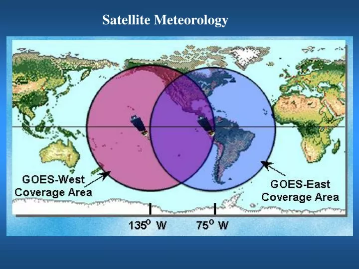
Geostationary Satellites http://www.oso.noaa.gov/goes/index.htm • Geostationary satellites orbit in the earth's equatorial plane at a height of 35,800 km. Note that the typical space shuttle orbit is only 225-250 km. • At this height, the satellite's orbital period matches the rotation of the Earth, so the satellite seems to stay stationary over the same point on the equator. It always view the same geographical area, day or night. • This is ideal for making regular sequential observations of cloud patterns over a region with visible and infrared radiometers • High temporal resolution and constant viewing angles.
WHY 35,800 km?? Gravitational force Centrifugal force Period: 24 h
GOES-15 GOES-13
ADVANTAGES OF GEOSTATIONARY ORBITS • Make repeated observations over a given area (constant view area) • Get high temporal resolution data. GOES E and W can give you a temporal resolution of 1 minute!! Hence, GOES E and W can effectively monitor the severe weather environment and track severe storms and hurricanes in real time. DISADVANTAGES OF GEOSTATIONARY ORBITS Due to the high orbit, the spatial resolution of the data is not as great as for the polar orbiting satellites Poor spatial resolution in the polar regions (parallax).