Download
1 / 44
460 likes | 1.02k Views
Atmospheric Circulations. Prof. John Toohey-Morales, CCM St. Thomas University Miami Gardens, Florida. Scales of Motion. Circulations exist in all sizes within the atmosphere

E N D
Atmospheric Circulations Prof. John Toohey-Morales, CCM St. Thomas University Miami Gardens, Florida
Scales of Motion • Circulations exist in all sizes within the atmosphere • Microscale: Eddies a few meters or less formed by convection or by wind blowing past obstructions, lasting at most a few minutes
Scales of Motion (continued) • Mesoscale: Circulation ranging from a few kilometers to about 100 km in diameter which can last hours or a day • Thunderstorms • Tornados • Local Winds
Scales of Motion (continued) • Synoptic: Weather map scale of hundreds or thousands of kilometers, lasting days or weeks
Scales of Motion (question) • An example of mesoscale motion is a. winds on a surface weather map of North America. b. winds on a 500 mb chart. c. winds blowing through a city. d. winds blowing past a chimney. e. the average wind patterns around the world.
Scales of Motion (question) • An example of mesoscale motion is a. winds on a surface weather map of North America. b. winds on a 500 mb chart. c. winds blowing through a city. d. winds blowing past a chimney. e. the average wind patterns around the world.
Local Wind Systems: Sea Breeze and Land Breeze • A type of thermal, mesoscale circulation setup by the uneven heating rates of land and water • Leading edge is the sea breeze front (Florida has 2), where in humid air thunderstorms can form to provide abundant rains
Local Wind Systems: Monsoon • Monsoon winds change direction seasonally, blowing from one direction in summer and the opposite direction in winter • In India & SE Asia the Monsoon lasts from June to September and although it doesn’t rain every day, most of the year’s rainfall accumulates during that time • Also seen in southwest USA in summer (AZ, NM, NV & south CA)
Local Wind Systems (questions) • A sea breeze circulation is caused by differences. a. humidity b. temperature c. altitude d. surface roughness
Local Wind Systems (questions) • A sea breeze circulation is caused by differences. a. humidity b. temperature c. altitude d. surface roughness
Local Wind Systems (questions) • Surface low pressure becomes best developed over the Asian continent in the a. summer. b. winter. c. fall. d. spring.
Local Wind Systems (questions) • Surface low pressure becomes best developed over the Asian continent in the a. summer. b. winter. c. fall. d. spring.
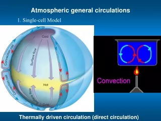
Global Winds • Earth’s general circulation is driven by unequal heating of the surface, with warm air transported poleward and cool air equatorward • The Hadley Cell is the simplest theoretical form to visualize the global circulation
Go to Visualization Three-Cell Model of Circulation • More realistic depiction of the general circulation • Three cells per hemisphere have the task of energy redistribution
Prevailing Winds • Doldrums are near the equator where the air is warm, PGF is weak, and winds are light. In the vertical the air is rising. • Trade Winds blow at the surface in the tropics and subtropics toward the low near the equator. Where they meet they form the Intertropical Convergence Zone (ITCZ)
Prevailing Winds (continued) • Poleward at 30° latitude you find the horse latitudes with light winds under subtropical high pressure, where air descends in the vertical after arriving from the equator on the Hadley Cell • The descending air diverges, part of it heading poleward but deflected by Coriolis to form the westerlies
Prevailing Winds (continued) • Surface air moving away from the poles out and under the polar high meets the westerlies at the polar front near 60° latitude, where air rises and storms develop on the subpolar low. The rising air diverges aloft, either into the Polar Cell or the Ferrel Cell
Prevailing Winds (questions) • Chicago, Illinois (latitude 42o N) is located in the a. northeast trades. b. southeast trades. c. westerlies. d. doldrums.
Prevailing Winds (questions) • Chicago, Illinois (latitude 42° N) is located in the a. northeast trades. b. southeast trades. c. westerlies. d. doldrums.
Prevailing Winds (questions) • At Barrow, Alaska (latitude 70o N), you would expect the prevailing wind to be a. northerly. b. easterly. c. southerly. d. westerly.
Prevailing Winds (questions) • At Barrow, Alaska (latitude 70° N), you would expect the prevailing wind to be a. northerly. b. easterly. c. southerly. d. westerly.
Prevailing Winds (questions) • Generally, along the polar front one would not expect to observe a. temperatures on one side lower than on the other side. b. an elongated region of lower pressure. c. clouds and precipitation. d. converging surface air. e. sinking air aloft.
Prevailing Winds (questions) • Generally, along the polar front one would not expect to observe a. temperatures on one side lower than on the other side. b. an elongated region of lower pressure. c. clouds and precipitation. d. converging surface air. e. sinking air aloft.
Prevailing Winds (questions) • On a weather map of the Northern Hemisphere, one would observe the westerlies a. north of the subpolar lows. b. south of the tropical highs. c. between the doldrums and the horse latitudes. d. between the subpolar lows and the subtropical highs.
Prevailing Winds (questions) • On a weather map of the Northern Hemisphere, one would observe the westerlies a. north of the subpolar lows. b. south of the tropical highs. c. between the doldrums and the horse latitudes. d. between the subpolar lows and the subtropical highs.
Prevailing Winds (questions) • In terms of the three-cell general circulation model, the driest regions of the earth should be near a. the equator and the polar regions. b. the equator and 30° latitude. c. the equator and 60° latitude. d. 30° latitude and 60° latitude. e. 30° latitude and the polar regions.
Prevailing Winds (questions) • In terms of the three-cell general circulation model, the driest regions of the earth should be near a. the equator and the polar regions. b. the equator and 30° latitude. c. the equator and 60° latitude. d. 30° latitude and 60° latitude. e. 30° latitude and the polar regions.
Prevailing Winds (questions) • The "roaring 40s" are strong surface winds found near 40°S latitude. Would these be EASTERLY or WESTERLY winds? (circle one answer)
Prevailing Winds (questions) • The "roaring 40s" are strong surface winds found near 40°S latitude. Would these be EASTERLY or WESTERLY winds? (circle one answer)
Semi Permanent Highs & Lows • The general 3-cell circulation results in high pressure at the poles and at 30° latitude, while low pressure is seen at the equator and 60° lat. • These shift slightly with the seasons, north in summer and south in winter
Semi Permanent Highs & Lows • Notable highs include the Bermuda High and Pacific High • Notable lows include the Aleutian Low and the Icelandic Low • The Siberian High is a seasonal high, while the monsoon is an example of a seasonal thermal low
Common Precipitation Patterns • Areas of high precipitation exist in the tropics near the ITCZ as well as between 40° & 60° latitude where low pressure and the polar front force air upwards • Deserts can be found near 30° latitude and at the poles with subsiding dry air related to high pressure
Highs Surrounding the U.S. • The position of the Pacific High plays a crucial role in determining the precipitation pattern of California and the Pacific Northwest • The Bermuda High provides for fair weather, except where it pumps moisture from the Caribbean and Gulf of Mexico into the eastern United States
Highs Surrounding the U.S. (question) • The Pacific high moves NORTH SOUTH in the summer. Because of RISING SINKING air along its eastern side, relatively DRY WET conditions prevail along the California coast. (choose one word from each pair)
Highs Surrounding the U.S. (question) • The Pacific high moves NORTH SOUTH in the summer. Because of RISING SINKING air along its eastern side, relatively DRY WET conditions prevail along the California coast. (choose one word from each pair)
Go to Visualization Jet Streams • Polar jet moves S in winter and N in summer • Isotachs are lines of equal wind speed and aid in locating jet streams • Found at the tropo-pause between 33K and 46K feet high • Are less than 1 mile thick with winds sometimes exceeding 100 mph • Situated where there are great temperature contrasts, like at the polar front
Jet Streams (question) • In the Northern Hemisphere, the polar jet stream is strongest when a. air north of the polar front is much colder than air south of the polar front. b. air north of the polar front is much warmer than air south of the polar front. c. air temperatures on opposite sides of the polar front are about equal. d. air temperatures on the East Coast of the US are much colder than on the West Coast of the US.
Jet Streams (question) • In the Northern Hemisphere, the polar jet stream is strongest when a. air north of the polar front is much colder than air south of the polar front. b. air north of the polar front is much warmer than air south of the polar front. c. air temperatures on opposite sides of the polar front are about equal. d. air temperatures on the East Coast of the US are much colder than on the West Coast of the US.
Important Ocean Currents • Currents are started by friction from the winds • 40% of heat transport from the tropics to the poles comes solely from ocean currents • Gulf Stream moves up the eastern U.S. coast and on to northern Europe via the North Atlantic Drift • California Current carries cool water south along the west coast of the U.S.
El Niño / Southern Oscillation • Southern Oscillation is the breakdown of the typical pressure patterns at opposite ends of the Pacific which leads to weaker E to W trade winds • Leads to El Niño, with warm tropical western Pacific water spreading east towards the South American coast
El Niño / Southern Oscillation (continued) • El Niño occurs at irregular intervals every 2 to 7 years, differing both in strength and behavior • Opposite condition known as La Niña
ENSO Consequences • Additional warmth & moisture leads to heavy rain and floods in Ecuador & Perú, as well as more hurricanes and typhoons in the eastern and central Pacific Ocean • Other areas like Indonesia, South Africa & Australia experience drought, and the Atlantic sees less hurricanes • California and the Gulf Coast sees heavy rain with the enhanced subtropical jet stream
ENSO Consequences (cont.) • Total worldwide damage can exceed $8 billion • Better forecasting of ENSO could come from extensive studies of the phenomenon since 1985