Download
1 / 15
160 likes | 313 Views
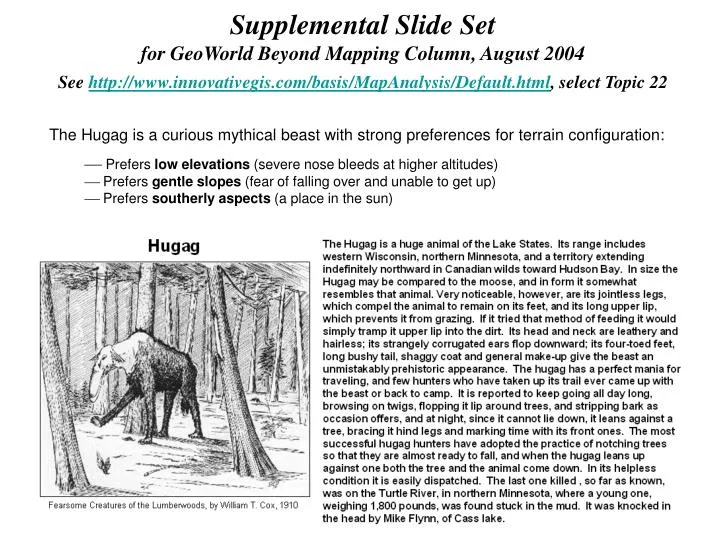
Supplemental Slide Set for GeoWorld Beyond Mapping Column, August 2004 See http://www.innovativegis.com/basis/MapAnalysis/Default.html , select Topic 22. The Hugag is a curious mythical beast with strong preferences for terrain configuration:

E N D
Supplemental Slide Set for GeoWorld Beyond Mapping Column, August 2004 See http://www.innovativegis.com/basis/MapAnalysis/Default.html, select Topic 22 • The Hugag is a curious mythical beast with strong preferences for terrain configuration: • Prefers low elevations (severe nose bleeds at higher altitudes) • Prefers gentle slopes (fear of falling over and unable to get up) • Prefers southerly aspects (a place in the sun)
0 1500ft …how would you map Hugag habitat? • Hugags like… • Gentle Slopes • (under 30%) • Southerly Aspects • (E-W orientation) • Lower Elevations • (under 1800 feet)
0 1500ft Manual Drafting Too Steep • Hugags like… • Gentle Slopes • (under 30%) • Southerly Aspects • (E-W orientation) • Lower Elevations • (under 1800 feet)
0 1500ft Manual Drafting Not southerly • Hugags like… • Gentle Slopes • (under 30%) • Southerly Aspects • (E-W orientation) • Lower Elevations • (under 1800 feet)
0 1500ft Manual Drafting • Hugags like… • Gentle Slopes • (under 30%) • Southerly Aspects • (E-W orientation) • Lower Elevations • (under 1800 feet) Too High
Not Southerly Too Steep Too High Manual Map Overlay Too High Not Southerly Too Steep 0 1500ft Manual Drafting – McHarg Overlay • Hugags like… • Gentle Slopes • (under 30%) • Southerly Aspects • (E-W orientation) • Lower Elevations • (under 1800 feet)
0 1500ft Computer Solution Too Steep = 0 • Hugags like… • Gentle Slopes • (under 30%) • Southerly Aspects • (E-W orientation) • Lower Elevations • (under 1800 feet) = 1
0 1500ft Computer Solution Not southerly = 0 • Hugags like… • Gentle Slopes • (under 30%) • Southerly Aspects • (E-W orientation) • Lower Elevations • (under 1800 feet) = 1 = 1
0 1500ft Computer Solution • Hugags like… • Gentle Slopes • (under 30%) • Southerly Aspects • (E-W orientation) • Lower Elevations • (under 1800 feet) Too High = 0 = 1 = 1 = 1
0 1500ft Binary Overlay • Hugags like… • Gentle Slopes • (under 30%) • Southerly Aspects • (E-W orientation) • Lower Elevations • (under 1800 feet) = 1 = 1 = 1 Times 1 * 1 * 1 = 1
0 1500ft Ranking Overlay • Hugags like… • Gentle Slopes • (under 30%) • Southerly Aspects • (E-W orientation) • Lower Elevations • (under 1800 feet) = 1 = 1 = 1 Plus 1 + 1 + 1 = 3
Gentle Slopes • (under 30%) • Southerly Aspects • (E-W orientation) • Lower Elevations • (under 1800 feet) = 1 = 2 = 4 Plus 1 + 2 + 4 = 7 0 1500ft Binary-Progression Overlay 1 2 4
0 1500ft Rating Overlay (Goodness Scale 1 to 9) Hugags like… (on a scale of 1 worst to 9 best) Gentle Slopes = 5.0 (22%) Southerly Exposed = 6.0 (West) Lower Elevation = 5.0 (1,300) Average 5.0 + 6.0 + 5.0 = 5.3
Good 9 OK= 4.5 Bad 1 Lake 0 0 1500ft Constraints Overlay Hugags like… Habitat Rating Bad= 1 to Good= 9 Covertype Water Mask Water= 0 Land= 1 Lakes Water = 0 times any Habitat Rating = 0
Hugags like… Gentle Slopes, Southerly Aspects, Lower Elevations Applying the Average Suitability model to a larger area shows its strong relationship to terrain configuration. Note that the areas of best habitat (dark green) occur on the fairly gentle slopes that are southerly oriented and at lower elevations. Note that the worst areas (bright red) occur on steep, northerly slopes at higher elevations. Best Habitat Best Habitat (West) (South) Suitability draped over 3D plot of Elevation