Download
1 / 23
260 likes | 757 Views
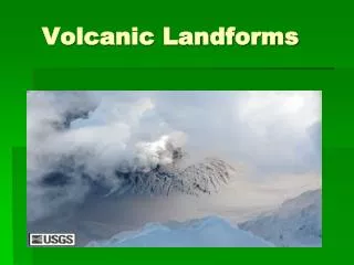
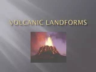
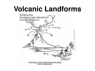
Volcanic Landforms. Key Idea: The shape of a volcanic landform is determined by the materials produced during an eruption. What are volcanic landforms?.

E N D
Volcanic Landforms Key Idea: The shape of a volcanic landform is determined by the materials produced during an eruption.
What are volcanic landforms? • The term volcano refers not only to a volcanic vent, but also to the landform that develops as the materials from a volcanic eruption harden. • The shape and structure of a volcano are determined by the nature of the eruption and the materials that are ejected during the volcanic activity.
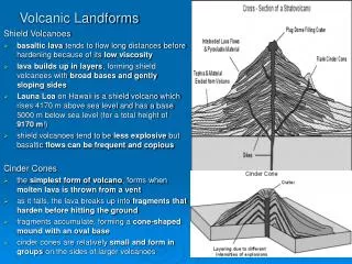
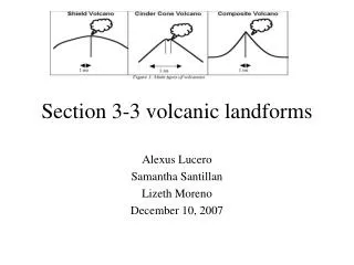
There are Several Kinds of Volcanoes: Mountain like landforms: • Shield Volcanoes • Cinder Cones • Composite Volcanoes Lava Plateaus-
Shield Volcanoes • Shield volcanoes ... are built almost entirely of fluid lava flows. Flow after flow pours out in all directions from a central summit vent, or group of vents, building a broad, gently sloping cone of flat, domical shape, with a profile much like that a warrior's shield. They are built up slowly by the accretion of thousands of flows of highly fluid basaltic (from basalt, a hard, dense dark volcanic rock) lava that spread widely over great distances, and then cool as thin, gently dipping sheets. These are the lest explosive volcanoes.
Cinder Cones • A cinder cone is perhaps the simplest type of volcano; it forms when molten lava is thrown into the air from a vent. As it falls, the lava breaks into fragments that solidify in the air, before hitting the ground. These fragments accumulate in a cone shaped mound. • Cinder cones tend to be smaller than other types of volcanoes. • They form in groups, and on the sids of larger volcanoes.
Composite Volcanoes • Sometimes called Stratovolcanoes, Composite volcanoes form when runny lava escapes through a fissure and flows a long way. Composite volcanoes are tall cone-shaped mountains that are typically steeply-sided, symmetrical cones of large dimensions. The essential feature of a composite volcano is a conduit system through which magma from a reservoir deep in the earth's crust rises to the surface. The volcano is built up by the accumulation of material erupted through the conduit and increases in size as lava, cinders, ash etc. are added to its slopes.
Composite Volcanoes • Composite volcanoes erupt in different ways at different times. These volcanoes are built in layers by multiple eruptions, sometimes recurring over hundreds of thousands of years, sometimes over a few hundred. Andesite magma (the most common but not the only magma type), tends to form composite cones. During some eruptions, cinders, bombs and blocks form a mountain or add height to one that earlier volcanic eruptions had built. During other eruptions, lava flows cement these rocks together.
Composite Volcanoes • Most composite volcanoes have a crater at the summit which contains a central vent or a clustered group of vents. Lava either flow through breaks in the crater wall or from fissures on the flanks of the cone. Lava, solidified within the fissures, form dikes that act as ribs which help to strengthen the cone. They may rise as much as 8,000 feet above their bases.
Composite Volcanoes • Some composite volcanoes occur in chains and are separated by several tens of kilometers. There are many composite volcano chains on earth, notably around the Pacific rim, known as the "Rim of Fir
Composite Volcanoes • Other examples of composite volcanoes and their locations are: • Mount St. Helens - Washington State • Mount Rainier - Washington State • Mount Vesuvius - Italy • Mayon Volcano - Luzon Island, Philippines • Mount Fuji - Japan • Mount Cotopaxi - Ecuador • Mount Shasta - California • Mount Hood - Oregon
Composite Volcanoes • St. Augustine volcano-Alaska is a composite volcano
Calderas • A caldera is a very large crater shaped basin, which forms when the top of the volcano collapses inward. This happens when the eruption empties the underground magma chamber, and leaves an “empty” space underneath.
Calderas • Chocosuela caldera-Costa Rica
Lava Plateaus • Sometimes at plate tectonics boundaries, there are long, narrow cracks (fissures) in the crust. Basaltic lave pouring from the fissure spreads across the land, forming a lava plateau.
Predicting Eruptions • Most volcanic eruptions are highly destructive. The destructive power of the volcano is given by many factors: • The gasses can be poisonous • Hot ashes could kill people in no time (Vesuvius destroyed two cities by covering them in hot ashes in 79 A.D.; people were burnt alive) • The lava, or volcanic bombs have also tremendous destructive power. • Tsunamis are seismic waves which are created by powerful earthquakes associated with violent eruptions.
Predicting Eruptions Facts: • About 15,000 volcanoes are categorized as active. Most are located along the Rim of Fire, in the Pacific Ocean. • 60 % of Earth’s population live close to the shore lines, around continents, which means that many people are at risk. • Can scientists predict volcanic eruptions?
Can scientists predict volcanic eruptions? • Many times it is a possible to predict an eruption. • For example, in April 1991 Mount Pinatubo (in the Philippines) started to give signs of activity. • The scientists set up a station to monitor its activity. They collected samples of gasses released at the summit of the mountain, they measured the seismic activity. By May they detected an increase in sulfur dioxide emissions, which meant the lava was approaching the surface. • In June they noticed that a side of the volcano was swelling. • Meanwhile the seismic activity was increasing.
Can scientists predict volcanic eruptions? • At Mount Pinatubo all evidence was suggesting that a large eruption was about to occur. • Fortunately the scientists and public officials had worked together to set up a plan for alerting the population. Eventually, about 200,000 people have been evacuated. • The volcano put out huge amounts of lahars (pyroclasic flows). Thousands of people have been saved.