Download
1 / 17
190 likes | 677 Views
Latitude and Longitude. Based on Discover God’s Creation by Rebecca K. Fraker. Where on Earth are we?. The ancient Babylonians originally divided any circle or sphere into 360 degrees. Ptolemy was a Greek thinker who borrowed their ideas as he wrote his book on geography.

E N D
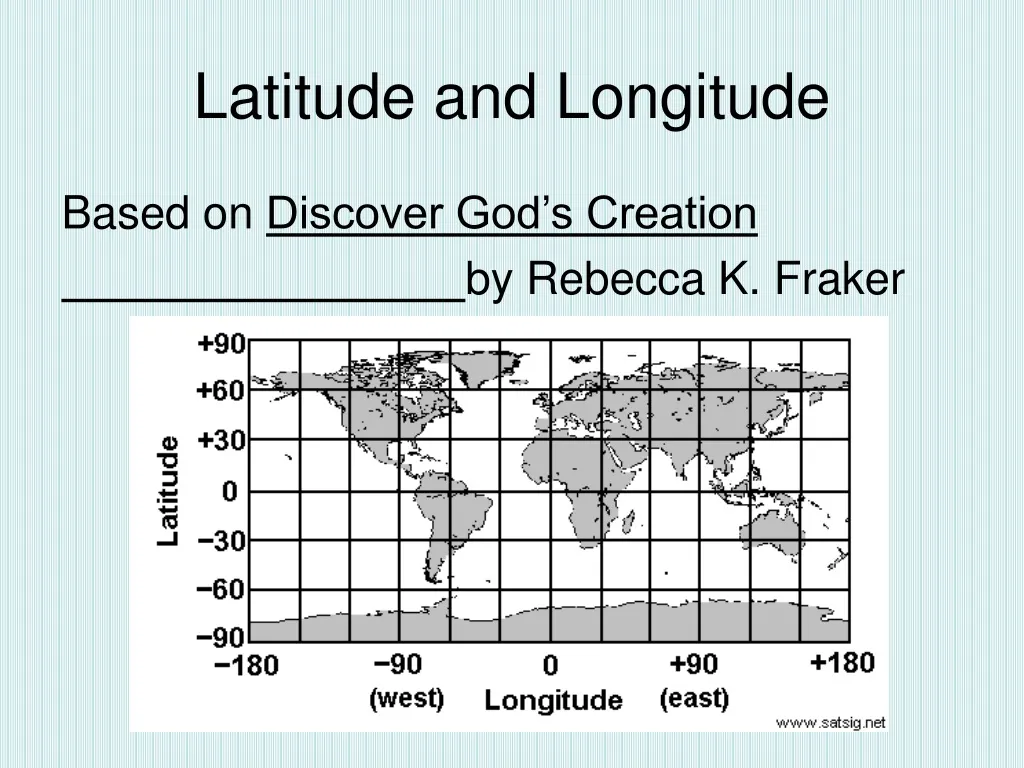
Latitude and Longitude Based on Discover God’s Creation by Rebecca K. Fraker
Where on Earth are we? The ancient Babylonians originally divided any circle or sphere into 360 degrees. Ptolemy was a Greek thinker who borrowed their ideas as he wrote his book on geography. There are 180 degrees between any two sides of a circle or sphere. The north and south poles are 180 degrees apart from one another, and both are 90 degrees from the equator. The equator is the imaginary line that is as far from the North Pole as it is from the South Pole.
Latitude The horizontal lines that circle the globe are called Lines of Latitude. Lines of Latitude are also known as parallels because they parallel, or run in the same direction as the Equator.
Longitude • The lines that run between the North and the South Poles are called Lines of Longitude, or meridians.
A longitude game http://www.pbs.org/wgbh/nova/longitude/find.html
Hemispheres • Geographers divide the earth into hemispheres. • Everything north of the equator is in the Northern Hemisphere, while everything south of the equator is in the Southern Hemisphere. • The Western Hemisphere is west of the Prime Meridian, while the Eastern Hemisphere is east of the Prime Meridian. The hemispheres both end at the International Date Line.
What hemisphere? .The United States is in the Northern and Western Hemispheres. West Palm Beach, is 80° west of the Prime Meridian and 27° north of the equator. This is commonly expressed as 27°N, 80°W
Prime Meridian • The line at zero degrees longitude is called the prime meridian. The prime meridian runs through the Royal Observatory in Greenwich, England. Meridians are counted east and west from the prime meridian, which is numbered zero degrees longitude. Prime Meridian 0 degrees longitude
International Date Line • The International Date Line is located 180 degrees, or as far away as possible, from the prime meridian. When it is noon along the prime meridian, it is midnight along the International Date Line. On the other side of the world from the Prime Meridian is the International Date Line.
Astrolabe • These pictures are of astrolabes. Find out what role they played in history.
Label the Latitude and Longitude 0º Longitude,45º E 90º N90º S 180º W 0º Latitude 45º N45º S135º W90º W45º W90º E135º E180º E
Games on line • There are many fun places online to practice latitude and longitude. • http://www.fourmilab.ch/earthview/ (Put in the coordinates and see the spot from space.) • http://www.pbs.org/wgbh/nova/longitude/find.html • http://www.studyworksonline.com/cda/explorations/main/0,,NAV2-5,00.html • http://members.aol.com/bowermanb/mapgames.html