Download
1 / 1
20 likes | 285 Views
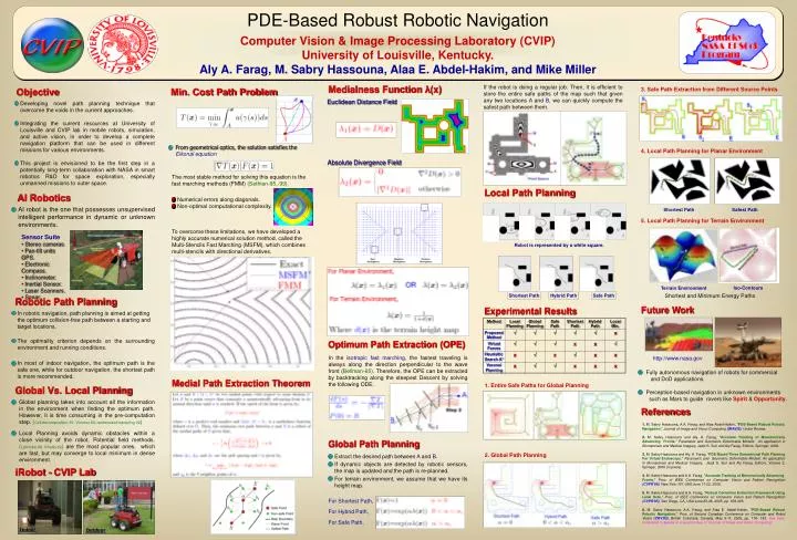
Shortest Path. Safest Path. Robot is represented by a white square. Shortest Path. Safe Path. Hybrid Path. Indoor. Outdoor.

E N D
Shortest Path Safest Path Robot is represented by a white square. Shortest Path Safe Path Hybrid Path Indoor Outdoor PDE-Based Robust Robotic NavigationComputer Vision & Image Processing Laboratory (CVIP)University of Louisville, Kentucky.Aly A. Farag, M. Sabry Hassouna, Alaa E. Abdel-Hakim, and Mike Miller Medialness Function λ(x) If the robot is doing a regular job. Then, it is efficient to store the entire safe paths of the map such that given any two locations A and B, we can quickly compute the safest path between them. Objective Min. Cost Path Problem 3. Safe Path Extraction from Different Source Points Euclidean Distance Field • Developing novel path planning technique that overcome the voids in the current approaches. • Integrating the current resources at University of Louisville and CVIP lab in mobile robots, simulation, and active vision, in order to develop a complete navigation platform that can be used in different missions for various environments. • This project is envisioned to be the first step in a potentially long-term collaboration with NASA in smart robotics R&D for space exploration, especially unmanned missions to outer space. From geometrical optics, the solution satisfies the Eikonal equation 4. Local Path Planning for Planar Environment Absolute Divergence Field The most stable method for solving this equation is the fast marching methods (FMM) (Sethian-95,-99). Local Path Planning AI Robotics • Numerical errors along diagonals. • Non-optimal computational complexity. AI robot is the one that possesses unsupervised intelligent performance in dynamic or unknown environments. 5. Local Path Planning for Terrain Environment To overcome these limitations, we have developed a highly accurate numerical solution method, called the Multi-Stencils Fast Marching (MSFM), which combines multi-stencils with directional derivatives. • Sensor Suite • Stereo cameras • Pan-tilt units GPS. • Electronic Compass. • Inclinometer. • Inertial Sensor. • Laser Scanners. • Sonar. Iso-Contours Terrain Environment Shortest and Minimum Energy Paths Robotic Path Planning Future Work Experimental Results In robotic navigation, path planning is aimed at getting the optimum collision-free path between a starting and target locations. The optimality criterion depends on the surrounding environment and running conditions. In most of indoor navigation, the optimum path is the safe one, while for outdoor navigation, the shortest path is more recommended. Optimum Path Extraction (OPE) In the isotropic fast marching, the fastest traveling is always along the direction perpendicular to the wave front (Bellman-65). Therefore, the OPE can be extracted by backtracking along the steepest Descent by solving the following ODE. http://www.nasa.gov • Fully autonomous navigation of robots for commercial and DoD applications. • Perception-based navigation in unknown environments such as Mars to guide rovers like Spirit & Opportunity. Medial Path Extraction Theorem 1. Entire Safe Paths for Global Planning Global Vs. Local Planning Global planning takes into account all the information in the environment when finding the optimum path. However, it is time consuming in the pre-computation step. (Cell decomposition-91, Voronoi-00, randomized sampling-02) Local Planning avoids dynamic obstacles within a close vicinity of the robot. Potential fieldmethods.(Latombe-86, Khatib-92)are the most popular ones, which are fast, but may converge to local minimum in dense environment. References 1. M. Sabry Hassouna, A.A. Farag, and Alaa Abdel-Hakim, "PDE-Based Robust Robotic Navigation," Journal of Image and Vision Computing(IMAVIS), Under Review. 2. M. Sabry Hassouna and Aly. A. Farag, "Accurate Tracking of Monotonically Advancing Fronts," Parametric and Geometric Deformable Models: An application in Biomaterials and Medical Imagery, Jasjit S. Suri and Aly Farag, Editors, Springer, 2006. 3. M. Sabry Hassouna and Aly. A. Farag, "PDE-Based Three Dimensional Path Planning For Virtual Endoscopy,"Parametric and Geometric Deformable Models: An application in Biomaterials and Medical Imagery, Jasjit S. Suri and Aly Farag, Editors, Volume 2, Springer, 2006 (in press). 4. M. Sabry Hassouna and A.A. Farag, "Accurate Tracking of Monotonically Advancing Fronts," Proc. of IEEE Conference on Computer Vision and Pattern Recognition(CVPR'06), New York, NY, USA June 17-22, 2006. 5. M. Sabry Hassouna and A.A. Farag, "Robust Centerline Extraction Framework Using Level Sets," Proc. of IEEE Conference on Computer Vision and Pattern Recognition(CVPR'05), San Diego, CA, USA June 20-26, 2005, pp. 458-465. 6.M. Sabry Hassouna, A.A. Farag, and Alaa E. Abdel-Hakim, "PDE-Based Robust Robotic Navigation," Proc. of Second Canadian Conference on Computer and Robot Vision (CRV'05), British Columbia, Canada, May 9-11, 2005, pp. 176- 183. Has been nominated to appear in a special issue of "Journal of Image and Vision Computing". Global Path Planning 2. Global Path Planning Extract the desired path between A and B. If dynamic objects are detected by robotic sensors, the map is updated and the path is re-planned. For terrain environment, we assume that we have its height map. For Shortest Path, For Hybrid Path, For Safe Path, iRobot - CVIP Lab