Download
1 / 44
460 likes | 503 Views
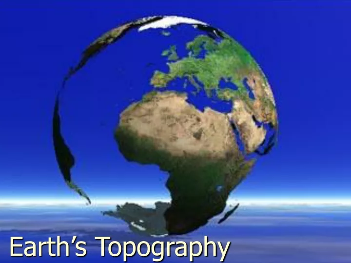
Earth’s Topography. Although our planet is called Earth, much of it is covered with water. All the land on Earth is surrounded by oceans How much of the Earth’s surface is covered with water? 25% 50% 70% 90%. Way to go! You’re on your way to becoming a topography wiz.

E N D
Although our planet is called Earth, much of it is covered with water • All the land on Earth is surrounded by oceans • How much of the Earth’s surface is covered with water? • 25% • 50% • 70% • 90%
Way to go! You’re on your way to becoming a topography wiz Click the image to continue
Major Land Divisions All the land on Earth can be categorized as being one of the following: • Landmasses • Continents • Islands
Landmasses • Landmasses are areas of land consisting of one or more continents • There are only four major landmasses • Asia, Africa and Europe • North, South and Central America • Antarctica • Australia
Continents • Continents are landmasses that measure millions of square kilometers and rise a considerable distance above sea level • There are seven continents • Africa • Antarctica • Asia • Australia • Europe • South America • North America
Islands • Islands are small landmasses which are completely surrounded by water • Which of the following continents is also an island? Africa Australia South America
Way to go! You know your continents Click the image to continue
Sorry, your answer was incorrect Click the image to go back and try again
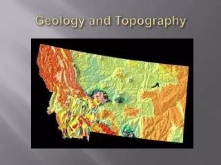
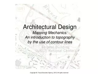
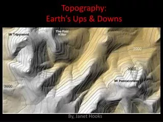
Topography • Topography refers to the shape of the Earth’s surface • The surface of the Earth is changed by • Weather conditions • Running water • Earthquakes and volcanoes • People
Earth’s topography is made up of different kinds of landscapes • Landscapesare the physical features of the Earth’s surface • Landscapes are defined by their • Elevation- Height above sea level • Relief-The difference in a region’s elevation • There are three main types of landscape regions • Mountains • Plains • Plateaus
North American Landforms
Mountains • Natural landforms that reach high elevations • Rise at least 600 meters above the surrounding land • Have narrow summits, steep slopes, and high relief
Shaping Mountains • Mountains result from the folding and breaking of Earth’s surface due to movements of portions of the crust • Can be created when hot magma from within the Earth breaks through the surface • Streams and rivers often carve valleys in mountains
Groups of Mountains • Mountain range-A roughly parallel series of mountains that have the same general shape and structure • Mountain system- A group of mountain ranges in an area • Mountain belt-A large group of mountains which includes mountain ranges and mountain systems
Plains • Plains are flat areas that have very small differences in elevation • Areas of low relief • Characterized by broad rivers and streams
Coastal Plains • Coastal plainsare low, flat areas located along a coast • Formed when soil and silt were deposited on the edge of a continent • The fertile soil makes farming a major activity
Interior Plains • Interior plains are low flat areas found inland on a continent • Elevations are higher above sea level than coastal plains • Sediments deposited by rivers and streams make the soil good for farming
Plateaus • Plateaus are broad, flat areas of land that rise more than 600 meters above sea level • Surfaces are fairly flat • Have low relief • Most plateaus are located inland • Often have the same landscape for thousands of kilometers • Many plateaus of the world are dry, nearly desert like
Introduction to Maps • Map-A drawing of the Earth, or part of the Earth, on a flat surface • Globe- A spherical, orround, model of the Earth • The most accurate representation of the entire surface of the Earth • Shows the shapes, sizes, and locations of all the Earth’s landmasses and bodies of water
Map Scales • Both maps and globes are drawn to scale • The scale compares distances on a map or globe to actual distances on the earth’s surface • The more closely the map approaches the land in size, the larger the scale will be
Waysto show scale on a map Verbal Fractional Graphic
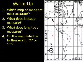
Parallels • Parallelsare lines going from east to west across a map or globe • Imaginary lines that completely circle the Earth • Cross meridians at right angles • Used to measure latitude
Latitude • Latitude- Measure of distance north and south of the equator • Lines are numbered in degrees from 0° at the equator to 90° at the poles • Latitudes must be labeled as being either north or south of the equator • One degree of latitude is equal to approximately 69 land miles
Meridians • Meridians- Lines that run between the geographic North and South poles of the Earth • Each meridian represents half of an imaginary circle around the Earth • Prime Meridian- The meridian running through Greenwich, England (0° longitude) • Used to measure longitude
Longitude • Longitude- Measure of distance east and west of the prime meridian • Lines are numbered in degrees from 0° at the prime meridian to 180° at the international date line • Longitudes must be designated as being either east or west of the prime meridian • Unlike lines of latitude, meridians are not parallel (farthest apart at the equator and get closer as they near the poles)
Time Zones • Time zone- A longitudinal belt on the Earth in which all areas have the same local time • The Earth has been divided into 24 time zones that are 15° wide • Why 15° wide? • 360° (deg. in a circle) 24 (hrs in a day) • There are 4 time zones in the contiguous United States (eastern, central, mountain, & pacific) = 15° (movement per hour)
Determining Local Time • When you cross from one time zone to another, the local time changes by one hour • Traveling east- you add one hour for each time zone you cross • Traveling west- you subtract one hour for each time zone you cross
Crossing the International Date Line • The international date line is a special meridian (180° E or 180° W) • Not only do you change the time when you cross it, you also change the day • Traveling east- add one hour, but subtract a day • Traveling west- subtract one hour, but add a day
Maps • Maps show locations and distances • Since the Earth is not flat, all maps have some distortion • Causes changes in the shapes and sizes of landmasses and oceans • The smaller the area mapped, the less distortion
Projecting Our Globe Onto A Flat Surface • Globes are the most accurate way to represent the surface of the Earth • Since it’s not practical to carry a globe into the field, map makers must figure out how to represent a round map on a flat piece of paper
Mercator or Cylindrical Map Projections • A Mercator or cylindrical projection map is the most common type of map that we see • It’s like projecting an image of the globe on a movie screen that’s been wrapped around it • Areas close to the equator have very little distortion • The closer to the poles that one travels the more distorted the map becomes • Used for navigation
Conic Projections • A conic projection map is created by placing a cone shaped screen on a globe • Produces a fairly accurate representation of the portion of the Earth’s surface being mapped • Used for making topographic maps
Gnomonic or Plane Projection • A gnomonic or plane projection is created by placing an imaginary screen directly above, or below a globe • Used to plot the shortest distance between two points • Since it distorts both direction and distance, this type of map projection is seldom used
Interrupted Projection • There are many different types of interrupted projection maps • Depict the continents as accurately as possible by leaving blank space in the less important areas of the map, such as in the oceans
Equal-Area Projection • For equal-area projections the meridians and parallels are placed on the map so that every part of the Earth is the same size on the map as it is on the globe • Correctly shows the amount of area a landmass covers, but distorts its shape
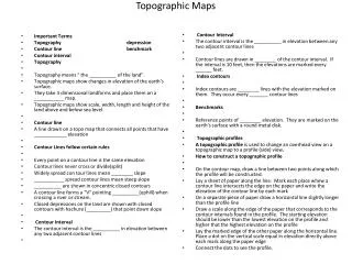
Topographical Maps Topographic maps show the different shapes and sizes of land surfaces • Show small details of the topography of an area • Shows the location of landscape and cultural features • Showtherelief, or elevation change, of the land
Contour Lines • Most topographic maps use contour lines to show the relief of the land • Contour line- A line that passes through points on a map that have the same elevation (height above sea level) • Index contour- A bolder/wider brown line that has the elevation value marked at various intervals as a part of the line • These contours typically occur every fifth line • Use an index contour near the point for which you are trying to find the elevation as a first step to determining the elevation of that point
Contour Interval • Contour interval- The difference in elevation from one contour line to the next • The size of the interval depends on the relief of the land (mountains will need a bigger interval than a plain) • To calculate the contour interval, determine the distance between two successive index contours and then divide that number by 5 Step 1:800 ft – 700 ft = 100 ft Step 2:100 ft ÷ 5 = 20 ft The contour interval would be 20 ft
Rules for using contour lines • Contour lines never cross or intersect • Closely spaced lines represent a steep slope • Contours spaced far apart represent a gentle slope • Contour lines that cross a valley are V-shaped • Contour lines form V’s that point upstream, or in a direction opposite the flow of the stream • Contours form closed loops around hilltops or depressions • Short dashes called hachures are used to indicate a depression • All contour lines either close or extend to the edge of a map
Mapping Etiquette To make reading and using a map easier, all maps should have a: • Title- to know what you’re looking at • Compass rose or north facing arrow- to determine direction • Map scale- to determine distance • Map key (or legend)- to explain symbols used • Way to determine the contour interval on topographic maps
Reading A Topographic Map Spectacle Island Contour interval = 3 meters Elevation of the shoreline = ? Elevation of the north drumlin = ? Elevation of the visitor center = ? Elevation of the highest point = ? How deep is the ocean off the southwest tip of the island ?