Download
1 / 18
180 likes | 436 Views
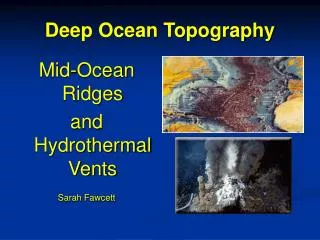
Ocean Topography. t opo= a place graphy= write. Why do we care?. Curiosity Understanding oceanic life Understanding natural disasters like : tsunami, earthquakes Locating natural resources. Ocean Topography.

E N D
Ocean Topography topo= a place graphy= write
Curiosity • Understanding oceanic life • Understanding natural disasters like: tsunami, earthquakes • Locating natural resources Ocean Topography
More than half of Earth’s solid surface is at least 3,000 meters below sea level.
That part of the continental landmass that extends from the lowest- low tide line to where it drops steeply to the ocean floor. It includes the shelf, slope and rise. Continental Margin
The shallow submerged extension of the continent- thick crust made of granite which is less dense than the ocean (basaltic) crust. They can have hills, depressions, sedimentary rocks, and minerals and oil deposits similar to those on the continent. Composes 7.4% of the earth’s ocean area. Continental Shelf
Can you guess why the bones of mastodons and humans have been found on the ocean floor?
Shelves are generally a flat, gentle terrain. This landform is characterized by periods of erosion followed by periods of sedimentation as the sea rises and falls.
The widths of a shelf are directly related to “plate activity”. • Narrow shelves are close to plate boundaries. • Wide shelves are located further away from the plate boundaries.
Average: • Slope- 1.9 m (10 ft.) • Depth- 35 m greatest- Antarctica (350m) • Width- varies 10 m – 1,300 km widest- Arctic ocean (Siberia) East coast of N. A. narrowest- W. coast of North and South America Shelf Averages
They receive nutrient-rich sediments from the continents. • These waters are shallow, light penetrates to the bottom. • Home to 80% Earth’s flora & fauna and yields 90% of the worlds harvest of fish & shellfish. • Source of oil, natural gas and minerals. Importance of the Continental Shelf
The part of the margin where the terrain takes a more rapid descent. It is usually narrow ranging from 6- 60 miles. W. Florida (Gulf) the slope is almost vertical. Off of Santiago, Chile- another steep drop. Continental Slope
Deep V- shaped cuts in the continental slope. Found near the mouths of large rivers. Up to 1 mile deep. Origins- • Ancient river channels • Extensions of canyons on land. Submarine Canyon
East coast – Hudson Canyon – 161 km (100 mi,) & approx. 3,658 m (12,000 ft.) deep. Submarine Canyons
West coast These canyons are rugged and twisted. Monterey Canyon- one of the most spectacular in the world. 97 K long (60 miles) & reaching depths of 3,048 m ( 10,000 ft.).