Download
1 / 27
270 likes | 382 Views
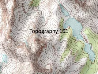
Topography. How maps show topography Hachure Isopleths Hypsography (water flows) Shading Contours. Hachure. Isopleths & Hill Shading. Hypsography (water flows). Contour Lines. All points along a contour line are the same elevation.

E N D
Topography • How maps show topography • Hachure • Isopleths • Hypsography (water flows) • Shading • Contours
Contour Lines • All points along a contour line are the same elevation. • Contour Interval is the elevation change between adjacent contour lines. • Most maps have major contour lines at a regular interval that are labeled with their elevation.
Contour Properties • The closer together the contour lines, the steeper the slope. • The fall line, or “straight down the hill” is perpendicular to the contour lines. This is the direction water would flow. • Water flows downhill and is a major force in shaping the topography.
Understanding Contour Lines • The key to making contour lines useful is learning how to translate from the “bird eye view” on the map, to what you see and experience as you hike through the terrain. • What will you see? • Will you be going uphill or down? • How steep will it be? • How will these things change as you move along your path?
Recognizing Basic Features • Hilltop, Mountain, Peak • Drainage, Canyon, Valley • Bluff, Cliff • Ridge • Saddle, Pass, Cut
What is the highlighted feature? How do you know?
What is the highlighted feature? It’s a hill top, summit, or peak. How do you know? The small “circle” contour lines are high points.
What is the highlighted feature? How do you know?
What is the highlighted feature? It’s a saddle, or pass How do you know? The “hourglass” shape with higher terrain on either side.
What is the highlighted feature? How do you know?
What is the highlighted feature? Steep terrain, possibly cliffs How do you know? Contour lines are very close together.
What is the highlighted feature? How do you know?
What is the highlighted feature? It’s a wide flat valley that gently slopes up to the NW. How do you know? Contour lines are far apart Terrain rises on either side Water runs down the middle Higher contour lines to the NW
What is the highlighted feature? How do you know?
What is the highlighted feature? It’s a ridge line. How do you know? A string of summits all in a line Terrain drops off on both sides
What are the highlighted features? How do you know?
What are the highlighted features? Intermittent streams How do you know? The blue line with dots The V like contour lines with the “sharp” end pointing upslope and towards a summit
What is the highlighted feature? How do you know?
What is the highlighted feature? It’s a ridge or finger How do you know? U or V shaped contour lines pointing down slope. Terrain drops off on both sides. It’s between two drainages.
What is the highlighted feature? How do you know?
What is the highlighted feature? It’s a drainage How do you know? V or U shaped contours pointing uphill. It “flows” into another stream or drainage