Download
1 / 1
10 likes | 93 Views
An Investigation of the Sky - CloudSat. Wagner Ranch Elementary Orinda, California Maddie, Kaiser, Grant, Giannie, Julia, Kate, Daniel, Will, Sonja, Edlyn, James, Lina, Ariel, Anya, Maddie, Jeffrey, Stephanie, Willie, Elena, Greer, Steven, Camille, Sophie, Ariana, Zach, Brian, Nolan, Carl.

E N D
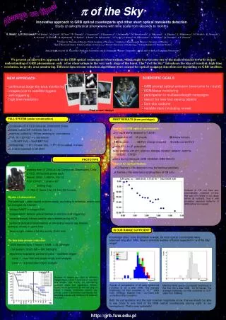
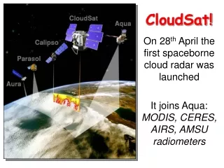
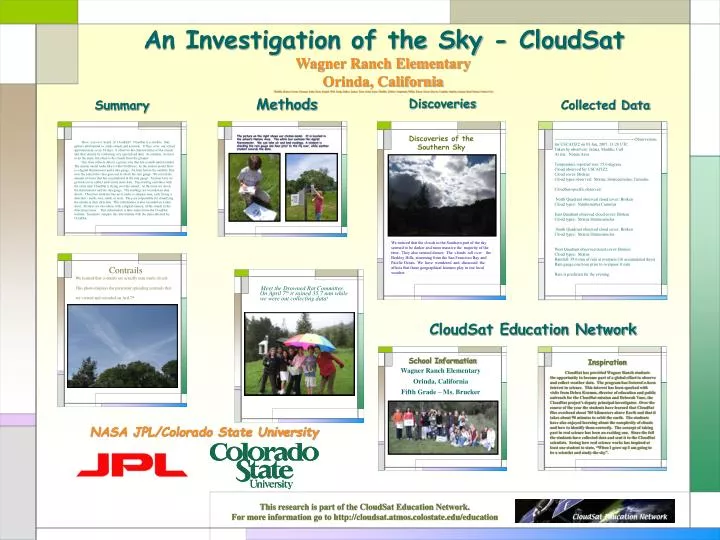
An Investigation of the Sky - CloudSat Wagner Ranch Elementary Orinda, California Maddie, Kaiser, Grant, Giannie, Julia, Kate, Daniel, Will, Sonja, Edlyn, James, Lina, Ariel, Anya, Maddie, Jeffrey, Stephanie, Willie, Elena, Greer, Steven, Camille, Sophie, Ariana, Zach, Brian, Nolan, Carl Methods Discoveries Collected Data Summary The picture on the right shows our station model. It is located in the school’s Nature Area. The white box contains the digital thermometer. We can take air and land readings. A student is checking the rain gauge one hour prior to the fly over, while another student records the data. Discoveries of the Southern Sky ----------------------------------------------------------Observations for USCAJ5Z2 on 03 Jan, 2007, 13:28 UTC Taken by observers: James, Maddie, Carl At site: Nature Area Temperature reported was: 15.6 degrees Cloud observed for USCAJ5Z2: Cloud cover: Broken Cloud types observed: Stratus, Stratocumulus, Cumulus CloudSat-specific observed: North Quadrant observed cloud cover: Broken Cloud types: Nimbostratus Cumulus East Quadrant observed cloud cover: Broken Cloud types: Stratus Stratocumulus South Quadrant observed cloud cover: Broken Cloud types: Stratus Stratocumulus West Quadrant observed cloud cover: Broken Cloud types: Stratus Rainfall: 39.6 mm of rain at overpass (16 accumulated days) Rain gauge one hour prior to overpass: 0 mm Rain is predicted for the evening. Have you ever heard of CloudSat? CloudSat is a satellite that gathers information to study clouds and aerosols. It flies over our school approximately every 14 days. It observes the characteristics of the clouds and their density by collecting very specialized data. As students, we have to do the same, but observe the clouds from the ground. Our class collects data in a grassy area that has a small station model. The station model looks like a white birdhouse. In the station model there is a digital thermometer and a rain gauge. An hour before the satellite flies over the school the class goes out to check the rain gauge. We record the amount of water that has accumulated in the rain gauge. An hour later we go back out to collect and record more data. This reading correlates with the exact time CloudSat is flying over the school. At this time we check the thermometer and the rain gauge. The readings are recorded on data sheets. Then four students line up to make a compass rose, each facing a direction - north, east, south, or west. They are responsible for classifying the clouds in their direction. This information is also recorded on a data sheet. Pictures are also taken, with a digital camera, of the clouds in the directional areas. This information is later entered into the CloudSat website. Scientists compare this information with the data collected by CloudSat. We noticed that the clouds in the Southern part of the sky seemed to be darker and more massive the majority of the time. They also seemed denser. The clouds roll over the Berkley Hills, stemming from the San Francisco Bay and Pacific Ocean. We have wondered and discussed the affects that these geographical features play in our local weather. Contrails We learned that contrails are actually man made clouds. This photo displays the persistent spreading contrails that we viewed and recorded on Aril 7th. Meet the Drowned Rat Committee. On April 7th it rained 35.7 mm while we were out collecting data! CloudSat Education Network School Information Inspiration Wagner Ranch Elementary Orinda, California Fifth Grade – Ms. Brucker CloudSat has provided Wagner Ranch students the opportunity to become part of a global effort to observe and collect weather data. The program has fostered a keen interest in science. This interest has been sparked with visits from Debra Krumm, director of education and public outreach for the CloudSat mission and Deborah Vane, the CloudSat project’s deputy principal investigator. Over the course of the year the students have learned that CloudSat flies overhead about 705 kilometers above Earth and that it takes about 90 minutes to orbit the earth. The students have also enjoyed learning about the complexity of clouds and how to identify them correctly. The concept of taking part in real science has been an exciting one. Since the fall the students have collected data and sent it to the CloudSat scientists. Seeing how real science works has inspired at least one student to state, “When I grow up I am going to be a scientist and study the sky”. NASA JPL/Colorado State University This research is part of the CloudSat Education Network. For more information go to http://cloudsat.atmos.colostate.edu/education