Download
1 / 13
130 likes | 224 Views
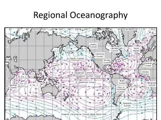
Ken Denman School of Earth and Ocean Sciences & Ocean Networks Canada University of Victoria, BC, Canada Email: denmank@uvic.ca. U. Victoria. Regional Oceanography Affecting the NEPTUNE Array. Winter/Summer Atmospheric Surface Pressure Patterns. http:// unimak.us / climate.shtml.

E N D
Ken Denman School of Earth and Ocean Sciences & Ocean Networks Canada University of Victoria, BC, Canada Email:denmank@uvic.ca U. Victoria Regional Oceanography Affecting the NEPTUNE Array INDEEP 24 April 14
Winter/SummerAtmospheric Surface Pressure Patterns http://unimak.us/climate.shtml INDEEP 24 April 14
Large Scale Surface Currents Summer Winter www.earthtimes.org INDEEP 24 April 14
Annual average surface NO3 concentrations (mmoles-N m-3) from the World Ocean Atlas From: Denman and Peña, 2000. In:The Changing Ocean Carbon Cycle, CUP. INDEEP 24 April 14
Mean SeaWiFS Surface Chlorophyll 1997-2010 http://oceancolor.gsfc.nasa.gov/ INDEEP 24 April 14
Oxygen on WOCE Line P01 at 48°N http://www.ewoce.org/ INDEEP 24 April 14
Silica on WOCE Line P01 at 48°N INDEEP 24 April 14
Northward Flowing California Undercurrent Over the slope200 - ~800 m Core around 400 m ‘Old’ water- low O2, low pH- high DIC, high dissolved nutrients Upwells in submarine canyons onto shelf during strong summerupwelling Krassovski, 2008. MSc ThesisUniversity of Victoria INDEEP 24 April 14
Seasonal Wind Stress – Vanc. Is. to Baja Huyer, A., 1983. Coastal upwelling in the California Current system, Prog. Oceanogr., 12:259-284. Arrows indicate direction of the wind and strength. Shaded ocean areas indicate high wind speed. INDEEP 24 April 14
Upper Water Chlorophyll Concentrations from Satellite Images Victoria Red indicates high chlorophyll concentrations on this colour scale INDEEP 24 April 14
Sea Surface Temperature Anomalies (°C) °C a b c Weakening El Niño March 1998 March 2012 October 2013 e f g La Niña Strong El Niño http://www.esrl.noaa.gov/psd/about/ INDEEP 24 April 14
Multiple Stressors: Decreasing arag& O2 Feely et al. 2008. Science 320:1490-1492 Dissolved Oxygen at 125 m, south of La Pérouse Bank in water 143 m deep. From: Crawford and Peña, 2013Atmosphere-Ocean, DOI:10.1080/07055900.2012.753028. Deptharag = 1 INDEEP 24 April 14
Thanks denmank@uvic.ca INDEEP 24 April 14