Download
1 / 26
260 likes | 544 Views
Science 3360. Lecture 16: Plate Tectonics A look at the historical development of the theory of plate tectonics. Questions to Answer. Two lectures ago we ended our discussion of the Rock Cycle with some nagging questions that need to be answered…

E N D
Science 3360 Lecture 16: Plate Tectonics A look at the historical development of the theory of plate tectonics
Questions to Answer • Two lectures ago we ended our discussion of the Rock Cycle with some nagging questions that need to be answered… • How does sedimentary material get transported to the deep interior where it can be metamorphized? • What causes uplift to move the igneous and metamorphic rocks to the surface to be weathered? • Where does the energy come from to drive this cycle? Teachnet-lab.org Wordpress.com
Aside: Scientific Laws • Theory and hypothesis are both often used colloquially to mean an untested idea or opinion. • According to the American College Dictionary: • Hypothesis: “a proposition or conjecture proposed as an explanation for the occurrence of some specified group of phenomenon.” • Often serves as the basis of argument or experimentation by which to reach the truth • Theory: “a coherent group of general propositions used as principles of explanation for a class of phenomenon • Law: “well established propositions that are regarded as reporting matters of fact
Plate Tectonics In the past two lectures we reviewed the basic properties of the solid earth and the minerals and rocks that we find on its surface. The rocks hint at the existence of a very dynamic earth. In this lecture we begin our discussion of Plate Tectonics Plate Tectonics represents a unified theory of the solid earth that explains many of the puzzles that we identified in previous lectures. But first we need to define two new regions…
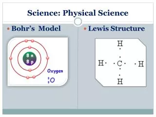
The Lithosphere and Asthenosphere The crust and upper mantle form 2 distinct regions: • The Lithosphere(comprising the first 70 - 125 km of the solid earth) consists of the oceanic and continental crustal material plus the uppermost portion of the mantle. It is rigid and acts as a single unit. • the Asthenosphere ( ~ 100’s km in depth) is characterized by low P-wave velocities. Because of these low velocities, geologists have deduced that this layer is plastic (i.e. not a liquid, but not rigid either) due to it probably being close to its melting point. As a result it: • provides source of material ejected in volcanoes • accounts for “rebound” of crust following ice ages • provides malleable layer upon which platescan flow
Plate Tectonics: The Origin • We start our discussion with the life of Alfred Wegener. • Alfred Wegener (1880 - 1930) • 1880 – Born • 1904 - Earned PhD in astronomy from University of Berlin • 1906 - Joined expedition to Greenland to study polar air circulation; took position at University of Marburg • 1911 - Began to formulate his theory of ”continental drift” • 1912-13 - joined another expedition to Greenland • 1914 - Drafted into the German army, but was released from combat duty after being wounded, and served out the war in the Army weather forecasting service. • 1915 - 1st edition of The Origin of Continents and Oceans published • 1924 - Took professorship in meteorology and geophysics at the University of Graz, in Austria. • 1930 - While returning from a rescue expedition that brought food to a party of his colleagues camped in the middle of the Greenland icecap, Wegener died, a day or two after his fiftieth birthday. • Acceptance of Wegener’s theory by the scientific community would not come for decades. Eiu.edu
The Continental Drift Theory • In 1908, Wegener read a paper on the similarities of fossils in North America and Europe. From this paper, Wegener pieced together evidence from a broad range of the Earth sciences to hypothesize that: • All of the present-day continents were once part of a single supercontinent called Pangaea • About 200 - 300 million years ago Pangaea had rifted, or split, and its pieces had been moving away from each other ever since
The Continental Drift Theory Evidence upon which Wegener built his hypothesis 1. The close fit between the coastlines of Africa and South America – actually fit is even better when using the continental shelf edges (i.e., the shoreline has been deformed by erosion). 2. Glacial features from essentially the same time period appear in South America, Africa, India, and Australia. This is perhaps is best explained if these continents were once connected.
The Continental Drift Theory More of the evidence upon which Wegener built his hypothesis. 3. Fossils of identical plants and animals found on all continents. This had been explained at the time by postulating that land bridges, now sunken, had once connected the continents. Glossopteris: grew in temperate, humid areas during Permian Period (245 – 285 million ybp. But fossil remains are found in rocks in regions with current climates ranging from tropical to polar.
The Continental Drift Theory • More of the evidence upon which Wegener built his hypothesis. • 4. Large-scale geological features on different continents matched when the continents were brought together (e.g., the Appalachian mountains in North America and those of the Scottish Highlands; the distinctive rock strata of the Karroo system in South Africa and those of the Santa Catarina in Brazil). • 5. Fossils found in some places do not match the current climates: • Glossopteri (see previous page) • Australian dinosaur fossils in Dinosaur Cove; • Fossils of tropical plants, such as ferns and cycads found on the Arctic island of Spitsbergen.
The Continental Drift Theory • Wegener constructed Pangaea by using the location of specific rock types to determine the distribution of climate zones in the geologic past. • Glacials from tills and striations were linked to polar climates • Sand Dunes were linked to deserts • Coral Reefs were linked to the tropics • The resulting distribution is quite different from today. There are two explanations of this: • The poles have wandered or • The continents have drifted
The Continental Drift Theory The motion of the continents. The white numbers represent millions of years from present. From the paleomap project
The Continental Drift Theory Wegener’s theory was not without problems or criticism. The main weakness was the lack of a viable mechanism for the “drifting continents”. Continents would have become deformed by the motion plowing through the ocean crust. We would expect to see large mountains along each coast which is not the case.
The Continental Drift Theory In 1928, Arthur Holmes proposed that convection currents – which bring hot magma (actually rock) up from the deep mantle and cooler rock downward - could drive continental motion. In the 1940's, sophisticated mapping of the seafloor during the WWII revealed a complicated chain of subsea volcanic mountains along the center of ocean basins forming a system ofMid-ocean ridges that appear as dark seams on the figure Waterencyclopedia.com
The Continental Drift Theory In the 1950’s, seismologists showed that the mid-ocean ridges were also an active seismic belt (or zone of earthquakes). It was proposed that the seismic belt corresponded to a trough, or rift, system running down the center of the ridges. The rifts are about 20 miles (30 km) wide and 6,500 feet (2,000 m) deep. In all, the oceanic ridges and their rifts extend for more than 37,500 miles (60,000 km) in all the world’s oceans. The mid-ocean ridge system represents the largest single volcanic feature on the Earth.
The Continental Drift Theory The Deep Sea Drilling Project (DSDP) was conceived in the mid-1960s but active drilling did not begin until 1968. The goal of the program was to investigate the evolution of the ocean basins by core drilling the ocean sediments and the underlying oceanic crust. Drilling operations were carried out aboard the Glomar Challenger, a 120m long ship built for the DSDP program. The Glomar Challenger was capable of drilling 2,500ft of sediment in 20,000 feet of water. Tracks of the Glomar Challenger from 1968-1975.
The Continental Drift Theory The DSDP revealed two very important pieces of information that would prove vital to the development of the theory of plate tectonics: The ocean floor is geologically young (no older than ~180 million year) The youngest rocks are near the central ridge and get older as you move away from the mid-ocean ridges.
Sea Floor Spreading • In 1962 Harry Hess and Robert Dietz independently developed the theory of sea-floor spreading. • Their theories were based on the age variation seen on the previous slide and the fact that the ocean floor is basaltic which differs from continental rocks which are granitic What is the main difference between basaltic rocks and granitic rocks? • The theory of sea floor spreading says: • Magma comes to the ocean floor at mid-ocean ridges • The magma erupts at sub-sea volcanoes and produces new basaltic crust • The basaltic crust slowly spreads causing the ocean floor to move away from the central ridges • When the spreading ocean floor reaches a continent, it plunges underneath the continent (subduction) Why? Granitic material is less dense than basaltic material (more on this with isostasy) • New mountains are formed along the boundaries. More on this later.
Isostasy Ocean crust is composed primarily of basalt and has a density of 2.9 g/cm3. It’s relatively thin, about 5-7km. Continental crust is composed primarily of granite and has a density of 2.7 g/cm3. It’s relatively thick, about 25-50km. Granite is less dense than basalt so continental crust tends to “float” above oceanic crust. Continental crust is thickest beneath high mountain ranges and thinnest beneath lowlands. The lithosphere is supported by the asthenosphere. The amount of athenosphere displaced is equal to the mass of the overlying object
Isostasy We know that the amount of the athenosphere that is displaced is equal to the mass of the overlying object. Think of a placing a heavy ball onto a large balloon. What happens? Thick continental crust must have deep “root” below to support its weight. Some areas of continental lithosphere are not in isostatic equilibrium because the mass in that area has recently and abruptly changed. Isostatic equilibrium (or isostasy) refers to the balance between the gravitation downward pull and the upward buoyant force provided by the athenosphere. As continents erode, the base of granitic crust rises. Why? To maintain isostatic equilibrium. Does this make sense?
Isostasy As we saw earlier in the semester, we can calculate the buoyant force by using Archimedes’ Principle. A.P. states that the buoyant force on an object is equal to the weight of the fluid it displaces. It can be shown that the same percentage of an object will always be below the surface of the fluid. So a larger percentage of the heavier blocks remain under the surface. Same percentage of the blocks remain below the water because all the same density. If we have a large amount above, we have to have a large amount below Images from geology.ohio-state.edu
Isostasy What happens as a mountain range is eroded? The land will rise to compensate for the removal of the eroded material. This is to maintain isostatic equilibrium. This means that some of the rock that is visible may have spent much of its history under the ground. Using this information, how was Stone Mountain formed? Stone Mountain is granite, an intrusive metamorphic rock. It formed under the ground about 350million year ago. There are a few theories as to how it became exposed but the most accepted one appears to be as follows. Surface erosion caused the underlying material (which SM was a part of, along with metamorphic rock) to be lifted. Erosion caused the metamorphic rock to weather away, leaving the tougher, more erosion resistant granite of Stone Mountain visible.
Sea Floor Spreading Support for sea-floor spreading theory came from a study of the magnetic polarity of the basaltic material of the seafloor. Background:the earth’s magnetic polarity (i.e., which pole is north and which is south) has flipped many times in earth’s history. As lava cools and forms rocks, the material becomes magnetized in the direction of the earth’s magnetic pole at that time and remains that way. So the magnetic orientation of igneous rock tells us the polarity of earth’s magnetic field at the time the rock was formed. Thinkquest.org
Sea Floor Spreading In 1963, Vine and Mathews explained the pattern of magnetic anomalies in the oceanic crust. They proposed that the lava erupted at different times along the mid-ocean ridge and preserved the record of magnetic reversals. The creating of these magnetic anomalies requires sea floor spreading.
Almost There… Before we can have a fully functional theory of the dynamic Earth, we still have to answer a few questions. Why don’t the continents just break apart? and Where does the old seafloor go when it meets the continents? The Theory of Plates introduced by Dietz, McKenzie, and Parker in 1968 will wrap help. The theory of plates combines sea-floor spreading with the theory of continental drift. 1. Earth’s outer shell (the lithosphere) consists of rigid plates 2. The plates slide on the softer athenosphere 3. As the plates move, they carry both the continents and the oceans 4. When continents and oceans meet, a deep valley is formed and the ocean floor “subducts” beneath the continent.
Plate Tectonics • Continents do not plow through oceanic crust. Instead continents and oceanic crust are considered to be part of the plates that move on the plastic asthenosphere. • A driving force, convective currents, moves the plates. • Seafloor is constantly being regenerated so it is younger than continental crust • Seafloor moves toward continental boundaries where it subducts beneath the continents and melts, forming magma. Thus the oceans don’t fill up with sediment. • Sediments melted and then turned into igneous rock beneath the continents. Rocks are slowly pushed upward, where they can become exposed and weather. Thus the system does not run out of nutrients.