Understanding Estuary Classification in the NOAA Coastal Assessment Framework
90 likes | 206 Views
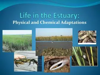
The NOAA Coastal Assessment Framework (CAF) establishes criteria for classifying areas as estuaries within the National Hydrography Dataset (NHD). The CAF serves as a digital spatial tool supporting effective coastal and marine resource management. It encompasses 150 estuarine drainage areas across the contiguous United States. These estuaries are categorized based on salinity zones: Seawater, Mixing, and Tidal Fresh. The framework aids in developing a national assessment capability for estuarine environments, enhancing data organization and presentation for resource managers.

Understanding Estuary Classification in the NOAA Coastal Assessment Framework
E N D
Presentation Transcript
The NOAA Coastal Assessment Framework (CAF) provides the basis for determining what areas will be classified as the NHD feature ESTUARY. The NOAA CAF metadata describes the CAF as “a digital spatial framework developed using geographic information system technology, which allows resource managers and analysts to organize and present information on the nation's coastal and marine resources. The CAF provides a consistently derived, watershed-based digital spatial framework for managers and analysts to organize and present information on the nation's coastal, near-ocean, and Great Lakes' resources. Within NOAA, it is the cornerstone of a series of ongoing efforts to develop a national estuarine assessment capability. Nation wide the framework is composed of 150 Estuarine (and sub-estuarine) Drainage Areas EDAs), 54 Fluvial Drainage Areas (FDAs), 324 Coastal Drainage Areas (CDAs), 12 Fluvial components of Coastal Drainage Areas (FCDAs), 11 interior watershed areas (self-contained, Groundwater-contributing only, or watersheds draining to outside the U.S.). The CAF encompasses 100 percent of the land area within the coterminous United States of America.” Salinity studies have further classified the 150 estuaries in the CAF as “Seawater Zone”, “Mixing Zone”, and “Tidal Fresh Zone”. Generally the NHD will include only the Seawater Zone and the Mixing Zone in the feature ESTUARY. The Tidal Fresh Zone will be classified as STREAM/RIVER. If applications require information on the tidal extent of a river, linear referencing can be used to delineate the tidal extent along the stream/river’s centerline. NOAA Coastal Assessment Framework digital data is available at: http://coastalgeospatial.noaa.gov/back_gis.html
Estuaries from the NOAA Coastal Assessment Framework Symbolized by Salinity Zone Tidal Fresh Zone Mixing Zone Seawater Zone
This turquoise is currently Lake/Pond In the NHD. It would become Estuary, Barataria Bay This blue is currently Sea/Ocean in the NHD. It would become Estuary, Barataria Bay This would be Sea/Ocean, Gulf of Mexico NHD waterbodies with NOAA CAF as crosshatch
Coastline would be used around the entire area classified as Estuary
These “bay” names can be captured as the NHD feature type Bay/Inlet. Local knowledge would be needed to create a polygon that represents the extent of the “named” feature. Bay/Inlet exists as a separate feature, “on top of” Estuary, Stream/River, Lake/pond