Download

1 / 6

E N D
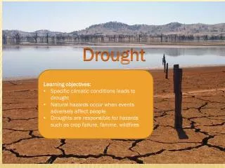
Drought • (1) Drought is a period of abnormally dry weather that persists long enough to produce a serious hydrologic imbalance (for example, crop damage, water supply shortage, etc.) The severity of the drought depends upon the degree of moisture deficiency, the duration, and the size of the affected area. • The NDMC uses this definition: "a deficiency of precipitation over an extended period of time, usually a season or more. This deficiency results in a water shortage for some activity, group, or environmental sector." • The latest NIDIS legislation uses the following: (e) DROUGHT DEFINED.—In this section, the term ‘‘drought’’ means a deficiency in precipitation— (1) that leads to a deficiency in surface or subsurface water supplies (including rivers, streams, wetlands, ground water, soil moisture, reservoir supplies, lake levels, and snow pack); and (2) that causes or may cause (A) substantial economic or social impacts; (B) substantial physical damage or injury to individuals, property, or the environment.
Wind River Basin • Current SNOTEL SWE is 70% of Average • Varies from 34 to 82% • Normal • SWE about 14 inches • Meltout starts about April 15 • Present • SWE about 10 inches • Runoff above Boysen • Into Boysen was 54% now 56% • Maximum was 71% of Average now is 77% Forecast Point PER MP MP% PER MP MP% -------------- ----- --- --- ----- --- --- WIND RIVER abv Bull Lake Cr APR-SEP 375 70 MAY-SEP 380 75 WIND RIVER at Riverton APR-SEP 395 62 May-SEP 360 59 BOYSEN RESERVOIR Inflow APR-SEP 435 54 MAY-SEP 425 56 BULL LAKE CR near Lenore APR-SEP 127 70 May-SEP 117 66 LT POPO AGIE RIVER nr Lander APR-SEP 33 62 MAY-SEP 34 69 SF LT WIND nr Fort Washakie APR-SEP 60 71 MAY-SEP 62 77 LT WIND RIVER nr Riverton APR-SEP 180 57 MAY-SEP 190 66
Big Horn River Basin • Current SNOTEL 75% of Average • Varies from 36 to 105% • Normal • SWE about 13 inches • Meltout starts about April 15 • Present • SWE about 10 inches • Runoff for Bighorn River • Basin at Kane is 60% of average • Maximum was 89% of Average Forecast Point PER MP MP% PER MP MP% -------------- ----- ---- --- ----- --- --- BOYSEN RESERVOIR Inflow APR-SEP 435 54 MAY-SEP 425 56 GREYBULL RIVER nr Meeteetse APR-SEP 135 68 MAY-SEP 136 70 SHELL CREEK nr Shell APR-SEP 64 89 MAY-SEP 59 86 BIGHORN RIVER at Kane APR-SEP 670 60
Shoshone River basin • Current SNOTEL 64% of Average • Varies from 27 to 85% • Normal • SWE about 19.5 inches • Meltout starts about April 15 • Present • SWE about 12.7 inches • Runoff • Basin Average is 77% of average • Maximum is 86% of Average • Minimum is 59% of average Forecast Point PER MP MP% PER MP MP% -------------- ----- --- --- ----- --- --- NF SHOSHONE RIVER at Wapiti APR-SEP 435 84 MAY-SEP 415 86 SF SHOSHONE RIVER nr Valley APR-SEP 167 63 MAY-SEP 179 70 SF SHOSHONE abv Buffalo Bill APR-SEP 145 64 MAY-SEP 126 59 BUFFALO BILL DAM Inflow (2) APR-SEP 605 75 MAY-SEP 545 72 CLARKS FORK RIVER nr Belfry APR-SEP 475 80 MAY-SEP 475 83
Powder-Tongue River basins • Current SNOTEL 91% of Average • Varies from 53 to 107% • Normal • SWE about 11.5 inches • Meltout starts about April 15 • Present • SWE about 10.5 inches • Runoff • Basin Average is 82% of average • Maximum is 98% of Average • Minimum is 72% of average Forecast Point PER MP MP% PER MP MP% -------------- ----- --- --- ----- --- --- TONGUE RIVER nr Dayton (2) APR-SEP 111 102 MAY-SEP 98 95 BIG GOOSE nr Sheridan APR-SEP 60 100 MAY-SEP 55 95 LITTLE GOOSE nr Bighorn APR-SEP 43 102 MAY-SEP 39 98 TONGUE RIVER RESERVOIR Inflow APR-SEP 240 96 MAY-SEP 210 93 MIDDLE FORK POWDER nr Barnum APR-SEP 13.6 73 NORTH FORK POWDER nr Hazelton APR-SEP 7.8 75 ROCK CREEK nr Buffalo APR-SEP 14.9 62 PINEY CREEK at Kearney APR-SEP 39 72 POWDER RIVER at Moorehead APR-SEP 145 63 MAY-SEP 143 72 POWDER RIVER nr Locate APR-SEP 160 62