Download
1 / 22
260 likes | 326 Views
Explore classical three-tier architecture of GIS software systems, desktop GIS implementations, and central server GIS setups for advanced departmental and enterprise use. Learn about various vendors and market shares in the GIS software industry.

E N D
Desktop GIS software architecture used in project GIS (A) standalone desktop GIS on PCs each with own local files (B) Desktop GIS on PCs sharing files on a PC file server over a LAN.
Client-server GIS: desktop GIS software and DBMS data server in a workgroup or departmental GIS configuration.
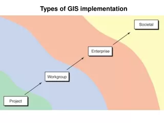
Centralized desktop GIS as used in advanced departmental and enterprise implementations
Centralized server GIS as used in advanced departmental and enterprise implementations
Clint Brown, Software Product Director (Courtesy Clint Brown)
GIS software vendor market share (Courtesy Daratech)
A geographic mashup of videos, pictures, and Wikipedia links on Google Maps
Architecture of MapServer The central boxes are the software components that read data, render maps, and fulfill other client requests. A Web server (open-source Apache or Microsoft IIS) is used to communicate with browser clients. (Source:http://mapserver.org/introduction.html)
Screenshot of Autodesk MapGuide—Server GIS (www.smamap.com/mapguide/SMAmap/index.php).
Google Earth (earth.google.com)
Microsoft Virtual Earth (www.bing.com/maps)
A Web application written using the ILOG JViews Map component toolkit
ESRI ArcPad running on a rugged hand-held field PC device
The Apple iPhone showing Google Maps—an example of a hand-held GIS (Courtesy Alex Singleton)