Download
1 / 19
220 likes | 404 Views
Boundary Layer Evolution. Atmos 3200/ Geog 3280 Mountain Weather and Climate. C. David Whiteman. Boundary layer definition.

E N D
Boundary Layer Evolution Atmos 3200/Geog 3280 Mountain Weather and Climate C. David Whiteman
Boundary layer definition • The boundary layer: The layer of fluid in the immediate vicinity of a fluid-solid boundary. In the atmosphere, the layer near the ground affected by diurnal heat, moisture and momentum transfer to or from the surface of the earth.
Tethersonde and radiosonde Whiteman (2000) Whiteman photo
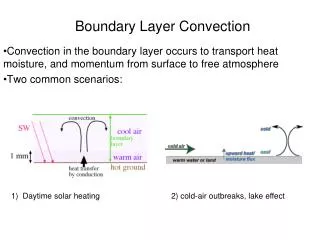
Typical evolution of boundary layer Whiteman (2000)
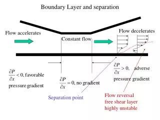
Temperature and potential temperature profiles Stull (2000) Stull (2000) Compare T and soundings FA = free atmosphere; EZ = entrainment zone; ML = mixed layer, SL = superadiabatic layer; CI = capping inversion; RL = residual layer; SBL = stable boundary layer
Diurnal fair weather evolution of bl over a plain Whiteman (2000)
Standard atmosphere Pressure decreases exponentially with altitude Pressure changes more rapidly in the vertical than in the horizontal, but the horizontal variations are important for visualizing traveling pressure systems. Standard atmosphere (tropo) 15°C at sea level Temperature lapse rate 6.5 °C/km
Pressure and wind units (also temperature) Wind speed conversion table • Pressure: • mb (hPa) • inches of mercury • mm of mercury • pounds per square inch • atmospheres • Winds: • mph (statute miles per hour) • m/s • knots (nautical miles per hour) • km/h Beaufort Wind Scale See Table 5.2 Demonstrate Kestral F = 32 + (9/5)C C = (5/9) (F-32) See Appendix D for unit conversions
Highs, lows, ridges, troughs Isoheight analysis, 500 mb Sea level pressure analysis Pressure variation on constant height surface (left) Height variation on constant pressure surface (rt) Isobar Isohypse, isoheight, contour line How to reduce surface pressure to sea level?
500 mb hemispheric pattern Mean 500 mb height pattern 25 Jan 1999 500 mb height pattern
Balance of forces, highs and lows, NH Balance of Forces: Pressure Gradient Force (PGF) is directed from high to low and is proportional to pressure gradient. Coriolis Force (CF) is a function of speed and latitude and is directed to right of wind. Friction Force opposes the wind and is proportional to surface drag. Above sfc friction, winds become parallel to isobars with low on left. If friction is felt, winds turn across isobars toward low pressure. Thus, winds spiral counterclockwise into sfc low and clockwise out of sfc high.
Leeward, windward, definitions Convention for naming winds: Named for the direction from which they blow Example: A north wind blows from N to S Example: An east wind blows from E to W A sea breeze blows from sea to land A land breeze blows from land to sea A mountain wind blows from mountain to valley A valley wind blows from valley to mountain If we need more specificity, use the bearing from which the wind blows Example: a wind from 178° (a south wind) Example: a wind from 87° (an east wind) Or use a vector Will need a legend or scale
Buys-Ballot rule (Northern Hemisphere) “If the wind blows into your back, the Low will be to your Left (and the high will be to your right).” This rule works well if the wind is above the earth’s boundary layer, not channeled by topography, etc.
Transfer of heat by cyclones and anticyclones Excess of solar radiation relative to long wave loss at equator. Deficit at poles. Poles get cold, equator gets warm. A zonal temperature gradient develops. Lows and highs and ocean currents are necessary to transfer heat from the equator toward the poles.
Diurnal variation of wind speed Winds at the ground increase in the afternoon as stronger winds are mixed down from aloft. Winds aloft decrease in the afternoon as the mixing exposes them to friction at the earth’s surface.