Download
1 / 22
230 likes | 429 Views
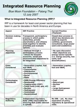
Integrated Transit Planning with TransMap. Presenter: Brian R. Sovik, GISP. http:// cfgis.org/FDOT-Resources/TransMap.aspx. What’s TransMap ?. Integrated multimodal decision support system Premium transit studies Inter and intra-agency coordination tool A one-stop-shop for transit.

E N D
Integrated Transit Planning with TransMap Presenter: Brian R. Sovik, GISP
What’s TransMap? Integrated multimodal decision support system Premium transit studies Inter and intra-agency coordination tool A one-stop-shop for transit
Interactive Tool Map Reports Queries • Flexible Project Incorporation • Work Mix • Phasing • Funding Source • Individual Project • Powerful Query Capabilities
Where is TransMap? • District Five • five transit authorities • five rail lines • one deep-water port • more than 160 public/private airports • Fastest growing district in Florida • covers nine counties • nearly 9,000 square miles • 3,688,400 residents • 55.6 million vehicle miles traveled daily.
CFGIS Content Management System with Geospatial Tools
The CFGIS Program .. Its Mission Provide a co-operative environment for GIS professionals & data 2. Promote communication, data sharing and provide spatial applications
tools right
The CFGIS Story – Partners who make it possible
FDOT Home on CFGIS – contains interactive tools & resources hosted on CFGIS (in partnership with ECFRPC)
The CFGIS “user” – shared across all Interactive Tools built On the CFGIS Platform
DRI General Viewer (using ArcGIS / ESRI JavaScript platform)
SISIM Map Viewer (using ArcIMS Platform)
Thank You. Brian R. Sovik, GISP Director of GIS-Transportation Solutions bsovik@dtsgis.com Direct Line (407) 608-7215 Mobile (407) 770-8611 www.dtsgis.com
Prime Contact Resource SANTANU ROY, PTP HDR Engineering, Inc. Senior Project Manager | Lead Modeler | Professional Associate 315 E. Robinson Street, Suite 400 | Orlando, FL 32801-1949 Direct: 407.420.4238 | Main: 407.420.4200 | Cell: 407.222.9971 Fax: 407. 420.4242 | Email:santanu.roy@hdrinc.com |hdrinc.com