Download
1 / 30
340 likes | 901 Views
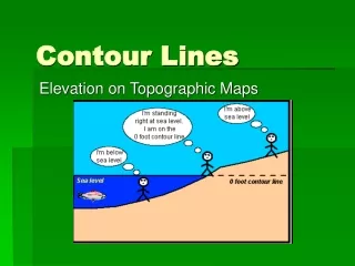
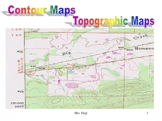
Contour Maps. Contour Lines. Contour lines are the most common method used to describe relief and elevation. Contour lines drawn on the map represent equal points of height above sea level.

E N D
Contour Lines Contour lines are the most common method used to describe relief and elevation. Contour lines drawn on the map represent equal points of height above sea level.
On multi-colored maps, contour lines are generally represented in brown. The map legend will indicate the contour interval — the distance in meters (feet, etc.) between each contour line.
There are 3 types of contour lines: • Index • Intermediate • Supplementary
Index Contour Lines Starting at mean sea level (zero), every fifth contour line is a heavier line with elevation for that line printed on it. For example, for most 1: 24,000 U.S. maps the contour interval is 10 feet, thus the index contour lines are every 50 feet.
Intermediate Contour Lines These are lighter contour lines that fall in between the index contour lines and do not have the elevation printed on them.
Supplementary Contour Lines These are dashed lines used to show sudden changes in elevation of at least on half the value of the contour interval.
Hills/Summits Hills or summits are depicted by closed rings of contour lines that get successively smaller towards the top.
Saddle A depression between 2 summits.
Steep Slope Contour lines are closely spaced.
Gentle Slope Contour lines are less closely spaced.
Spur • This is a sloping line of higher ground with lower ground on three sides. • It is depicted by 'U' or 'V' shaped contour lines with the closed end of those lines point towards the bottom of the finger (lower ground).
Valley • A valley is a stretched out groove in the land usually formed by streams or rivers. • Contour lines forming a valley are either 'U' or 'V' shaped with the closed end of the V points upstream towards higher ground.
Ridge • A ridge is a sloping line of high ground. • The contour lines forming a ridge tend to have a 'U' or 'V' shape with the closed end point away from the high ground.
Depression • This a low point in the ground or a sinkhole surrounded by higher ground all sides. • It is depicted by closed contour lines with hachures pointing inward toward the lower ground.
Cliff • This is a vertical or near vertical abrupt change in the land. • It is depicted by very closely spaced contour lines, or by converging contour lines into one contour line that is some times marked with hachures that point toward the lower ground.
Look at contour lines (A) and (B) on the map. • Note that (A) is at 7500 ft. and (B) is at 7600 ft. • Any line from (A) to (B), then, should be uphill.
A quicker way to find elevation changes is to use creeks and streams. • Since water travels downhill, finding the direction that a stream travels can quickly tell you about relief along the length of the watercourse.
On all streams, the V formed by contour lines always points upstream, and therefore uphill. • Look at the stream indicated by (D) on the map. Notice that when contour lines run into this stream, they form a 'V' shape that appears to point to the left. • Check the V shape at point (E). Even though the stream is in a relatively flat area, the upstream-pointing V is still visible.