Download
1 / 20
200 likes | 430 Views
Problems and Future Directions in Remote Sensing of the Ocean and Troposphere. Dahai Jeong AMP. Outline. Background Introduction Problem areas - directional ocean wave spectra - ocean surface winds - a subset of atmospheric measurements - air-sea interaction Conclusion.

E N D
Problems and Future Directions in Remote Sensing of the Ocean and Troposphere Dahai Jeong AMP
Outline • Background • Introduction • Problem areas - directional ocean wave spectra - ocean surface winds - a subset of atmospheric measurements - air-sea interaction • Conclusion
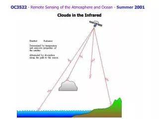
BackgroundTwo kinds of oceanic backscatter Reflection and scattering of a radiance that is normally and obliquely incident on specular and wave-coverd ocean surface
Bragg scatter • Strong oceanic backscatter for incident angles θ as up to 70º λw = λ/2sinθ where, λw = surface wavelength λ = surface projection of the radar wavelength • For near nadir incidence angles, σ0 ↓ as U ↑ For oblique angles, σ0 ↑ as U ↑ Bragg scatter generated by the interaction between and incident radiance and a specific water wavelength
Introduction • Purpose - identify the gaps and limitations in our ability to remotely sense the oceans and troposphere from air and space platforms
Directional Ocean Wave Spectra • Lack of remote sensing data - The spatially evolving directional wave number spectrum (~1000 km at best) - The temporally evolving directional wave number spectrum (~ a few days)
Directional Ocean Wave Spectra • Recent measurements - systematic spatial and temporal variability of the spectrum : impact on understanding of the physics of wind-wave generation, operational wave forecasting, ship routing, local global wave climatology, off shore tower design and coastal erosion research. - Seasat synthetic aperture radar (SAR) data - Surface contour radar (SCR) - Radar ocean wave spectrometer (ROWS)
Existing Methods and Techniques for Remote Measurement of Ocean Wave spectra
Summary and Conclusions • For further progress in the practical application of remote sensing techniques - Interrelationships between the ocean and the atmosphere at all levels - Analyses of data - Physical interpretation of the results for oceanographic significance - High-quality intercomparison data sets
Ocean Surface Winds• Problems with the SASS algorithm • Vertically polarized (VV) and horizontally polarized (HH) pairs of observation (upper panel) - discrepancies in the low-speed and high-speed ranges - agreeing only in the range 8-14 m/s (lower panel) - plot of speed difference, UHH-UVV (Woiceshyn et al.)
Basic Considerations in the Model Function Relating Radar Scattering to Ocean Surface Conditions • Correct wind measure • : problem of relating radar signal to wind speed - Power law or (based on friction velocity) where, σ° = scattering coefficient (NRCS) U10 = neutral-stability wind at 10 m α,є,b,ρ = constants for a given geometry - Donelan and Pierson : σ° have better correlation with where, U(λ/2) = average wind at half Bragg wave length above the surface C(λ) = phase speed of the Bragg resonant wave
Sea State, Currents, and Internal Waves • Modulations of the ripples - winds - sea state - currents - internal waves - slopes of the larger waves - rain striking the water
Experiments Needed • Continuing analysis of the wealth of data from Seasat • Analysis of data to be obtained with new spaceborne scatterometers in conjunction with well-designed surface comparison experiments • Properly designed aircraft measurements • Careful measurements from well-instrumented towers • Measurements to validate the ability to correct for the attenuation of a scatterometer signal using a coincident radiometer beam
Summary and Conclusions • No theory for backscatter at high wind speeds • What wind to use in specifying the relation ship between wind speed and radar return • Numerous measurements
Atmospheric Measurements • Winds, both surface and aloft • Temperature and water vapor profiles • Precipitation • Surface fluxes of heat, moisture, and momentum
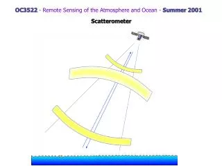
Measurement Methods • Surface winds - scaterometer - microwave radiometer - radar altimeter • Winds at altitude - airborne Doppler radar (ADR) - spaceborne Doppler lidar • Water vapor - passive microwave remote sensing • Precipitation - spaceborne visible or IR sensors
Air-Sea Interaction • Physics behind the correlation between surface winds or stress and the microwave signal • Planetary boundary layer: solar insolation is transferred to the atmosphere to drive the general circulation
Air-Sea Interaction • Important factor in scales - stratification in the PBL • Mesoscale phenomena - heat fluxes • Wave spectrum - microwave wind detection algorithms
Conclusion Remote sensing of the atmosphere and the ocean has demonstrated some of what can be done, but it has also illuminated vast areas of ignorance.