Download
1 / 37
380 likes | 563 Views
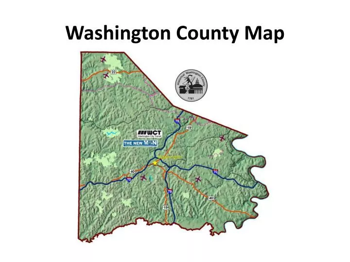
Washington County Map. 1. What is the title of this map?. Washington County Pennsylvania Highway Map. 2. What kind of map is this?. Road map. 3. Who prepared this map?. Washington County Commissioners. 4. When was Washington County formed?. March 28, 1781.

E N D
1. What is the title of this map? • Washington County Pennsylvania Highway Map
2. What kind of map is this? • Road map
3. Who prepared this map? • Washington County Commissioners
4. When was Washington County formed? • March 28, 1781
5. What is the address and phone number of the Washington County Planning Commission? • 100 W. Beau St., Suite 701 Washington, PA 15301 724-228-6811
6. What was Washington County’s population in 2000? • 202,897
7. How many square miles is Washington County? • 863.6 sq. mi.
8. Name Washington County’s highest point, its height above sea level, and the township it’s in. • Mt. Wheeler 1,523 ft. above sea level N. Franklin Twp.
9. Name Washington County’s lowest point, its height above sea level, and the township it’s in. • Elrama 760 ft. above sea level Union Twp.
10. What types of agricultural products is Washington County known for? • Milk & dairy
11. What is the annual value of agricultural production? • $38.0 million
12. What types of industrial products is Washington County known for? • Coal, primary & fabricated metals, electric machinery
13. What is the annual value of industrial production? • $1.8 billion
17. Name the two cities in Washington County. • Washington City & Monongahela City
18. What county was Washington County formerly part of? • Westmoreland County
19. Why was Washington County formed? • Wash. Co. was formed “to allow the inhabitants of the area west of the Monongahela R. to have more convenient courts & public offices rather than the inconvenience & hardship of being so far remote from the seat of justice & records in Westmoreland Co.”
20. The territory of Washington County was originally part of what state? • VA
21. Washington County gave rise to what three counties? • Allegheny, Greene, & Beaver Counties
22. What was the Whiskey Rebellion? • The Whiskey Rebellion (1791-1794) was when farmers & political leaders led in the protest of the Federal government’s excise tax on whiskey.
23. What Canonsburg landmark was associated with the Whiskey Rebellion? • Black Horse Tavern
24. What did the Rev. John McMillan establish? • The Rev. John McMillan established a log cabin academy (school) for boys near CBG.
25. What did John and Francis LeMoyne and Thomas McKeever do? • John and Francis LeMoyne used their home in Washington as a station for the Underground RR. • Thomas McKeever of West Middletown est. a similar station for escaped slaves.
26. Name the program that preserves farmland in Washington County. • Farmland Preservation Program
28. What is the phone number for the Canonsburg Borough building? • 724-745-1800
29. What are the coordinates for the Arden Trolley Museum, CUP, Cbg. Lake And Dam, Lindenwood Golf Course, Little Lake Dinner Theater, Mineral Beach, Mingo Creek Park, Maggi’s Golf Course, Franklin Mall, etc. • Arden Trolley Museum = C4 • CUP = G6 • Cbg. Lake And Dam = E3 • LindenwoodGolf Course = E4 • Little Lake Dinner Theater = E3 • Mineral Beach = F3 • Mingo Creek Park = E, F4 • Maggi’sGolf Course = E4 • Franklin Mall = C5
31. What color type is used to represent township Names? • GREEN
32. Boroughs and cities are represented by what color? • Yellow
34. What color is used to represent interstates? • Dark blue
36. How many miles is it from Canonsburg to Cecil, to Muse, to McDonald, to Washington, to Eighty-Four. • CBG to Cecil = 6 • CBG to Muse = 3 • CBG to McDonald = 9 • CBG to Washington = 6 • CBG to Eighty-Four = 7