Download
1 / 18
180 likes | 280 Views
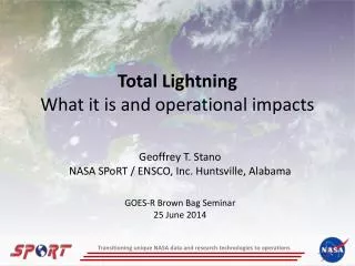
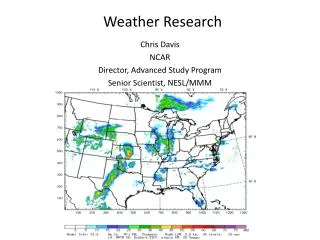
SPoRT Transitioning Research Data to the Operational Weather Community. NOAA Science Week April 30 – May 4, 2012, Kansas City. Gary Jedlovec NASA Marshall Space Flight Center Huntsville, AL and the SPoRT Team. Webpage: http://weather.msfc.nasa.gov/sport

E N D
SPoRTTransitioning Research Data to the Operational Weather Community NOAA Science Week April 30 – May 4, 2012, Kansas City Gary Jedlovec NASA Marshall Space Flight Center Huntsville, AL and the SPoRT Team Webpage: http://weather.msfc.nasa.gov/sport Blog: http://weather.msfc.nasa.gov/sportblog
Short-term Prediction Research and Transition (SPoRT) • SPoRT is focused on transitioning unique NASA and NOAA observations and research capabilities to the operational weather community to improve short-term weather forecasts on a regional and local scale. • Southern Region focus with collaborations in other Regions and OCONUS • SPoRT activities began in 2002, first products to AWIPS in February 2003 • SPoRT Paradigm • Match observations to forecast challenges • Develop and assess solution in “testbed” environment • Transition solution to decision support system • Develop/conduct training, product assessment and impact • Benefit • Demonstrate capability of NASA experimental products to weather applications and societal benefit • Prepares forecasters for use of data from next generation of operational satellites (NPP/JPSS, GOES-R)
SPoRT Focus • NASA data and research capabilities • MODIS, AMSR-E, AIRS, TMI (TRMM), WindSat, also SSMI, SSMI/S imagery, RGBs, and other derived products • Total lightning data from ground-based networks • Forecast model and initialization products available to WFOs and community – forecast impact of NASA data • Land Information System (LIS) - surface forcing with MODIS GVF and composite SSTs • GSI analysis (w/ AIRS, IASI profiles) – full operational suite of data w/ AIRS and IASI profiles • SPoRT WRF (with LIS/GSI analyses) • Improved situational awareness and forecast challenges such as reductions in visibility, convective and severe weather, surface processes, coastal weather, data voids • Products in AWIPS / NAWIPS at selected / collaborative WFOs and National Centers (SPC, HPC, OPC, NHC) • Transitioning NASA data to AWIPS II (HGX and HUN) • Training and product assessment / impact What Why How • New RGB products to WFOs • OCONUS collaborations • Suite of passive microwave products to National Centers • Transition to AWIPS II
GOES-R Proving Ground • Work with AWGs and PG partners to develop and transition GOES-R proxy products in area of expertise • Use NASA and other observations • GOES- POES hybrid • Multispectral difference and RGB composites • LMA / LDAR total lightning obs. for pseudo GLM applications • Products from AWGs (CI, QPE) and partners (GOES Sounder Air Mass RGB) • Demonstrate utility of baseline and selected research products and prepare forecasters for operational usage • Products in AWIPS / NAWIPS at subset of collaborative NASA / SPoRT WFOs and NCs • Participate various demonstrations (regional PG activities) with products and assessments – OCONUS • Training and product assessment / impact SPoRT Focus (continued) What Why How
GOES Sounder “Air Mass” Product Courtesy of Michael Folmer - HPC GOES Sounder Air Mass (CIRA) / Vorticity Products more useful when available in end user’s DSS
GOES-POES Hybrid Product to simulate or serve as “proxy” for GOES- R ABI While MODIS can be used to replicate spatial and spectral resolution of ABI, the polar orbit limits its temporal resolution Combine MODIS, VIIRS and GOES to simulate GOES-R ABI capabilities – both single channel and RGB imagery GOES-POES Air Mass RGB Hybrid GOES WV – MODIS RGB
PGLM and Lightning Jump Radar Reflectivity Pseudo GLM In conjunction with radar, the total lightning product can provide forecasters additional guidance on severe storm warnings.
GOES-R Proving Ground • Work with AWGs and PG partners to develop and transition GOES-R proxy products in area of expertise • Use NASA and other observations • GOES- POES hybrid • Multispectral difference and RGB composites • LMA / LDAR total lightning obs. for pseudo GLM applications • Products from AWGs (CI, QPE) and partners (GOES Sounder Air Mass RGB) • Demonstrate utility of baseline and selected research products and prepare forecasters for operational usage • Products in AWIPS / NAWIPS at subset of collaborative NASA / SPoRT WFOs and NCs • Participate various demonstrations (regional PG activities) with products and assessments - OCONUS • Training and product assessment / impact SPoRT Focus (continued) What • Actively work with 8 WFOs / 3 NCs • Assessments, blog posts, papers • RGB products • Transition to AWIPS II • VSP collaborations Why How
Suomi NPP / JPSS (VIIRS) • Engaging forecasters in an evaluation of selected products to address specific forecast challenges • Work with NESDIS and VIIRS imagery team • In the CONUS region - products / forecast issues related to convective storm diagnostics, reduction in visibility and ceilings, unpredicted variations due to local surface forcing • In OCONUS, atmospheric products to address nowcasting issues with additional emphasis on ocean products, particularly SST, ice characterization, and snow cover • Extend capabilities of MODIS and AIRS (use CrIS) products into future and prepare forecasters for operational use • Demonstrating capabilities in AWIPS / AWIPS II • Waiting on real-time direct broadcast data streams • Additional EDRs from NESDIS • Training and product assessment SPoRT Focus (continued) What Why How
VIIRS Heritage / Capabilities VIIRS DNB MODIS SeaWiFS AVHRR Ozone WV OLS Low Light Imagery 0.4 0.5 0.6 0.7 0.8 0.9 1.2 1.8 2.4 4 6 8 10 12 14 Modified NOAA Chart Breaks in scale Visible Mid wave IR Long wave IR [micron] Credit: Northrup Grumman & Raytheon
VIIRS Products in AWIPS / AWIPS II AWIPS (D2D) AWIPS II (CAVE) VIIRS imagery in Decision Support Systems (DSS) at various WFOs
VIIRS Day Night Band (DNB) • Low light sensor • Emission from light sources • cities • lightning • fires • Moonlight reflected from atmospheric and surface features • clouds, fog • snow • other reflective sfc • Envision many new applications including RGBs
RGB Products from VIIRS VIIRS Dust RGB
VIIRS / CrIS Air Mass RGB Products VIIRS / CrIS -- AIR MASS RGB MODIS -- AIR MASS RGB April 3, 2012 0807-0815UTC
Suomi NPP / JPSS (VIIRS) • Engaging forecasters in an evaluation of selected products to address specific forecast challenges • Work with NESDIS and VIIRS imagery team • In the CONUS region - products / forecast issues related to convective storm diagnostics, reduction in visibility and ceilings, unpredicted variations due to local surface forcing • In OCONUS, atmospheric products to address nowcasting issues with additional emphasis on ocean products, particularly SST, ice characterization, and snow cover • Extend capabilities of MODIS and AIRS (use CrIS) products into future and prepare forecasters for operational use • Demonstrating capabilities in AWIPS / AWIPS II • Waiting on real-time direct broadcast data streams • Additional EDRs from NESDIS • Training and product assessment SPoRT Focus (continued) What • Producing / formatting demonstration products for AWIPS / AWIPS II • Beginning collaborations with several WFOs • Waiting on RT data Why How
SPoRT at NOAA Science Week • SPoRT staff members: • Gary Jedlovec, Matt Smith, Andrew Molthan, Kevin Fuell, Kris White • Geoffrey Stano , Jason Burks • Presentations • SPoRT Overview (Monday ) – Gary Jedlovec • New AWIPS II Applications (Thursday) – Jason Burks • Current SPoRT AWIPS II Activities (Thursday) – Jason Burks • Joint RGB Project Overview and Status – Gary Jedlovec • RGB in AWIPS II – SPoRT Perspective – Kevin Fuell • Posters • Tuesday: #22 – SPoRT JPSS / VIIRS Activities • Thursday: #1 - NASA / SPoRT GOES-R Proving Ground Activities • #2 - Transition and Evaluation of RGB Imagery to WFOs • and National Centers • #21 - SPoRT AWIPS II Activities
SPoRT Summary • SPoRT is focused on: • core NASA objectives • demonstrating utility of selected GOES-R PG products in areas of expertise • using Suomi/JPSS (VIIRS) to extend MODIS capabilities and prepare forecasters for operational usage • We do this by: • Linking forecast challenges to products • Working with end users to develop solutions • Develop / conduct end user training • Transition products to relevant DSSs